Friday
One of the toughest and most rewarding mountains to hike in the Catskill Park: dramatic cliff bands, a pregnant tree, a steep and challenging summit. Plus a WWII bomber.
Peak Details
Height: 3,500ft (1,067m)
Range: Southern Catskills
Level: Hardest
Scenic: No/Low
Trail Type: Bushwhack
Canister: Yes
Friday Hiking Trails & Hikes
Friday, Balsam Cap & B-25 Crash Site
A long, tough, rewarding hike that follows woods roads and herd paths, and ends with a true bushwhack to the wreckage of a WWII military bomber.
The Six: Friday, Balsam Cap, Rocky, Lone, Table, Peekamoose
I was definitely nervous to go on this hike. I knew it was long and demanding. It crosses six mountains and some of the gnarliest terrain in the Catskills. But tackling it as part of a group made it a fantastic experience.
Friday Topography
Summit Forecast: Friday
The page URL below shows the weather at Friday’s summit for the next six days.
If a foreacast for a peak is not directly available, this page may display a link to a nearby location.
https://www.mountain-forecast.com/peaks/Friday-Mountain/forecasts/1126
Friday Information
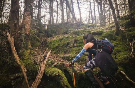
Friday mountain gives a lot of people a lot of trouble. The hike up its eastern ridge is tiring. The terrain is tricky. There are lots of places to get turned around. The summit woods are extremely thick — and the canister is nowhere near the summit.
For a first visit, your two best options are either to go with someone who can show you the landmarks, or to join one of the wonderful Catskill 3500 Club Group Hikes.
Two Approaches
There are two main approaches to climbing Friday (and/or Balsam Cap).
- Straight Up the Ridge Line: short and very steep, over rough footing; quite a tough climb IMO.
- The Woods Roads Route: essentially, a massive switchback that walks you around the first very tough mile of the more direct route, while keeping you away from private property; it’s also far more interesting.
Either way, you begin at the Moonhaw Road parking area. With your back to the stream, look for the start of the herd path. It’s just to the left of a DEC sign on a tree. A dirt groove connects right away with a steep woods road that brings you uphill to the right. On the way, you’ll have to climb over some large blowdowns.
Two Routes
After a minute or two, you can decide which route to take…
- Balsam Cap in The Clouds uses the Straight Up Route
- Hike Friday, Balsam Cap & B25 from Moonhaw uses the Woods Roads Route
Converge & Climb
Eventually, at around 2300’, both routes converge on a flat area in the middle of the ridge. This is a good spot for a rest break. It’s the only level part of the entire hike.
Your next objective is to keep to the center of the ridge-line and make your way to the C-Shaped Tree. The main herd path passes right by it — but there are several faint trails in the area, so stay close to the center of the ridge.
Not long after this, by tracking south west, you will connect with the Rim Trail and slowly make your way up past The Mailbox and Whale Rocks to the Pregnant Tree.
When you get to the Pregnant Tree, choose which mountain to do first: Friday or Balsam Cap. Most people start with Friday as it’s the tougher of the two.
Herd Path to Friday Mountain’s Summit
Ascend, following the herd path, which tracks up and to the right. You will quickly come face-to-face with a large rock wall. In fact, it’s only the lower section of an enormous ledge that extends hundreds of feet to your right. In winter, spectacular icicles hang from the entire length of the massive wall. Keep heading up along the base of the ledge. This is The Ramp — the only sane way up to Friday’s summit.
Directly above The Ramp, the herd path hits a T-junction. The easiest route to the summit is to your right.
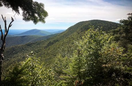
First, however, there is a very short detour to your left through the woods to a small ledge with an excellent scenic view of Balsam Cap, Ashokan High Point and the Ashokan Reservoir. If you’re lucky, the herd path will be clear, or there will be tracks in the snow you can follow.
After the scenic view, make your way back to the T-junction and now continue straight. Remember that this is a bushwhack and there is no correct way to make your way to the summit. But the herd path is pretty clear these days. Even when it splits, it’s heading to the same place. Follow the Rule of Up.
The terrain here is very rough and steep, and the evergreen forest is very, very dense. The soil is loose in spots. You will probably have to climb under some blowdown.
If you come to a large rock ledge at 3500’, make your way around it to the left; you have roughly 200’ of pretty steep vertical ascent to go.
The actual summit of Friday is deep in the dense woods. (There is no view. I checked.) In fact, the woods here are so thick that the Catskill 3500 Club has placed their canister several hundred east of the summit, on the side of the summit knob. The herd path to it is pretty clear. There is a small view of the Devil’s Path range.
Somewhere in those woods, reportedly, is a non-terrible route to Balsam Cap. For now, sadly, it’s the stuff of lore — I’m not aware of anyone who’s found an “easy” route. Most people who want to add Balsam Cap to their hike simply head back down to the Pregnant Tree.
Descend Friday Mountain
After signing the canister and enjoying the view, head back down the steep upper knob, back to the T-Junction, down The Ramp, and back out to The Pregnant Tree.
All things being equal, you will likely take a different route down to Moonhaw Road than you took up; it’s all in a day’s bushwhack.
Once you’re at the Pregnant Tree, the hike to Balsam Cap takes only 25 minutes and is far less difficult.
On the way back down to Moonhaw, if you have time and energy, you can also add a true (and very difficult) bushwhack to the largest plane wreck in the Catskills.
Get full access…
Get instant access to the full version of this site and enjoy great supporter benefits: full galleries, full trail notes, early access to the latest content, and more.
Hot on the website right now…
Follow for more…
Follow my @TotalCatskills content on Instagram for regular hiking inspo and safe, inclusive community.