Bash Bish
Steep, rugged, deadly mountain.
Peak Details
Height: 1,840ft (561m)
Range: Southern Taconics
Level: Moderate
Scenic: Yes
Trail Type: Fully Trailed
Bash Bish Hiking Trails & Hikes
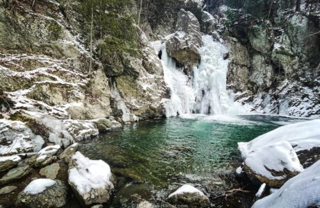
Bash Bish Falls
An easy walk leads to a spectacular payoff: Bash Bish Falls — Massachusetts’ highest waterfall.
Bash Bish Topography
Summit Forecast: Bash Bish
The page URL below shows the weather at Bash Bish’s summit for the next six days.
If a foreacast for a peak is not directly available, this page may display a link to a nearby location.
https://www.mountain-forecast.com/peaks/Alander-Mountain/forecasts/682
Get full access…
Get instant access to the full version of this site and enjoy great supporter benefits: full galleries, full trail notes, early access to the latest content, and more.
Hot on the website right now…
Follow for more…
Follow my @TotalCatskills content on Instagram for regular hiking inspo and safe, inclusive community.