Disclosure: This content may contain affiliate links. Read my disclosure policy.
These iPhone apps are the best hiking apps I’ve come across to date. I‘ve tested a bunch of apps and stopped using a lot of them. These are the apps I use over and over. They make my hiking life richer, safer, and much more enjoyable.
I’ve broken the apps into four categories: navigation/planning, field identification, photography, and fun.
I love these tools because they’re easy to use and don’t get in the way of the hiking experience. They keep me informed and they keep me safe. But they also enrich my hiking, and help me re-live and share my exploits. That’s why they’re the best hiking apps for 2020.
Whether you enjoy easy scenic trails or challenging mountain hikes, these apps will help you plan, plot and prepare for your next adventure.
= Highly Recommended

Best Hiking Apps: Great Navigation & Planning Apps
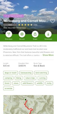
Avenza + NY-NJ Trail Conference Map (2018) Best for NY/NJ/Catskills
Quick Info: This combination of an app and a single in-app purchase is the very best way to navigate safely in the Catskills, as well as many other trails in New York and New Jersey. A blue dot appears at your exact location on the most thoroughly marked and best quality map of the region.
The Avenza app itself is very powerful and works with any geospatial PDF. You can download pre-existing geo-referenced PDFs or make your own. A partial list of Avenza’s main functions includes:
- Locate and show GPS position and compass direction
- Record GPS tracks during your activities
- Drop placemarks wherever you are and add notes or photos
- Measure distances and areas
- Overlay search engine results on any map for offline use
- Use built-in recreational symbols or import your own
- Access to almost one million maps in the Avenza Map Store in-app and online
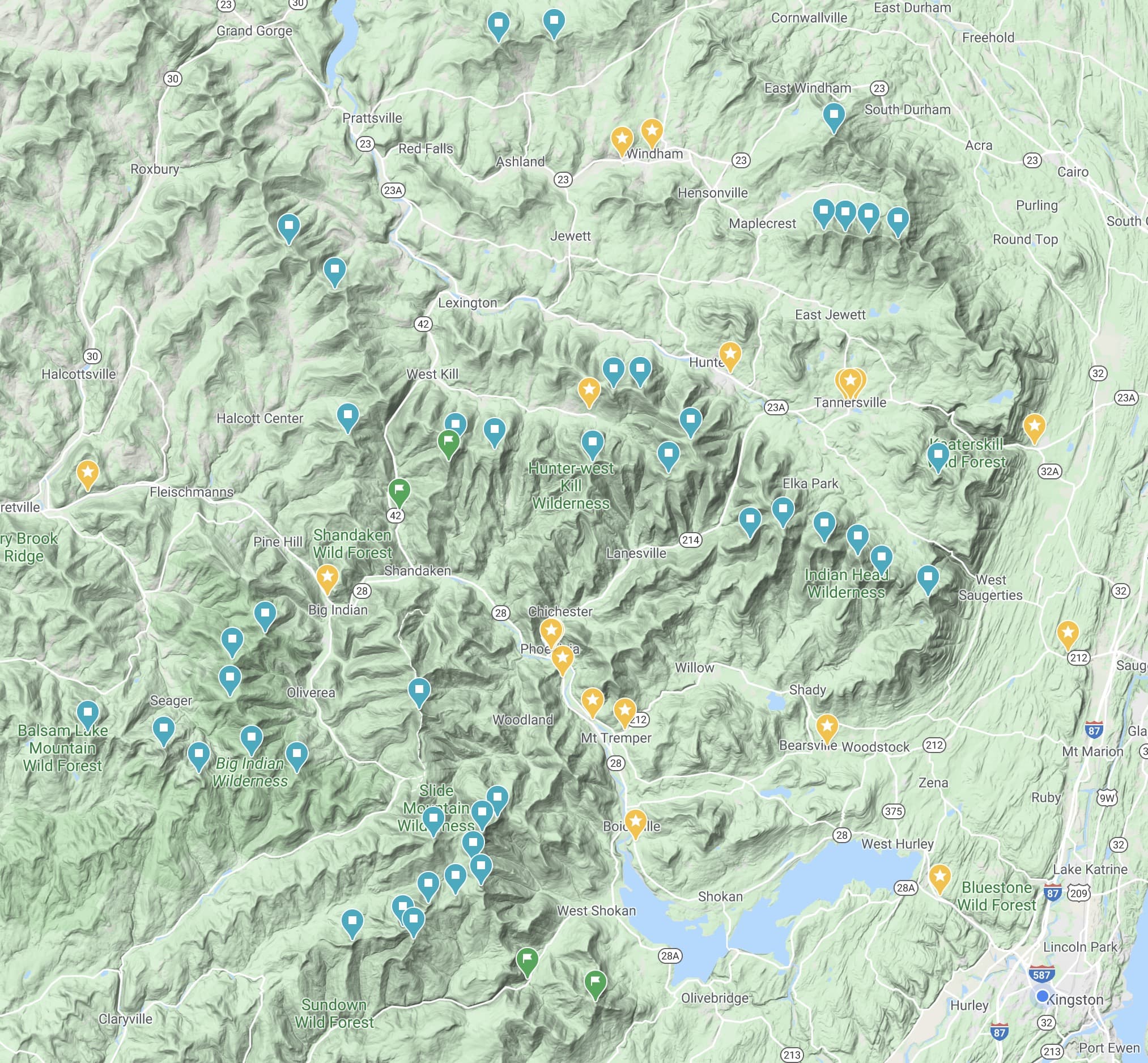
The beauty of the Trail Conference’s map speaks for itself. It’s extremely detailed and easy to read. On top of that, Avenza allows you to drop colored pins onto layers which can be switched on and off. I use various colored pins for various meanings…
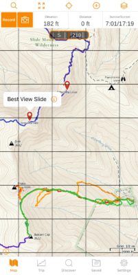
Avenza Pins & Layers
Below/Left (summits only): blue pins are summits I’ve bagged, while orange pins are summits I plan to bag.
Below/Right (summits and waypoints): green pins are great scenic views, yellow pins are important waypoints, and red pins are tricky/dangerous spots.
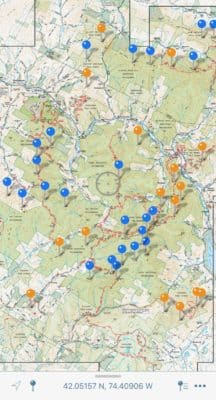
You can add helpful labels to the pins. Below, you can see the red pin has the label “Avoid (Steep)”.
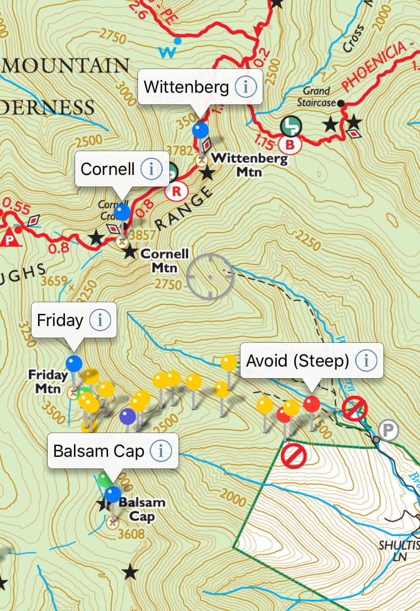
You can also attach photos and text notes to each pin. Tapping on the circled-i brings up a panel with a set of fields where you can add info and change the appearance of the pin.) It’s very straightforward and intuitive. Dropping a pin on location takes only a few seconds.
Pins can be moved between different layers. For example, I keep summits on one layer and waypoints on another. Sometimes I want to hide my waypoints for a minute to focus on what mountain I might climb next.
Cell Service & GPS
Like other phone nav systems, all these functions works without cell coverage. All modern smartphones use GPS for location finding and do not need cell towers or WiFi networks to do so. (Experienced hikers know to put their phones in airplane mode to conserve battery.)
For navigating the Catskill Park, the combination of this app with this map is the gold standard. That’s why it’s on this list of best hiking apps. It’s literally the first thing you should download.
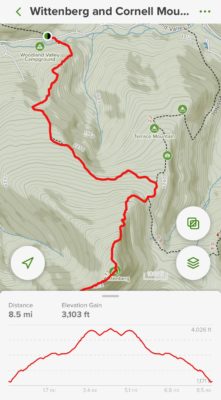
GaiaGPS Best for absolutely anywhere else
Quick Info: It’s hard to talk about GaiaGPS without gushing. It’s just so great. Its recently-updated, more beautiful and faster-loading topographic maps have just the right amount of detail for navigating, basically, anywhere on the planet.
No “best hiking apps” list would be complete without listing GaiaGPS which offers a powerful suite of hiking, navigation, and waypoint marking tools. First, there’s the phone app which is well-designed and extremely easy to use.
Record Your Track
Click the Record button (top left) at the start of your hike and… that’s it! The app will update your elevation, distance travelled, and total time as your hike progresses. Super easy.
The three small information panels at the top of the screen (to the right of the record and camera buttons) are changeable via a long press — I have mine set to: elevation, distance, and Sunrise/Sunset.
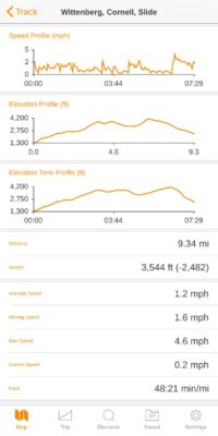
After your hike, stop recording, and Gaia shows a bunch of nice metrics:
- pace and elevation profiles
- total distance
- total elevation gain
- moving time
- average speed
- and so on
Avenza also allows you to record your movement as you hike, but I’ve found it to be flaky — and it’s not easy to share your tracks and data. In contrast, GaiaGPS offers rock-solid tracking and sharing.
Gaia’s Website
Tracks recorded on your phone are synced with your account on the GaiaGPS website. This allows you to store all your tracks long term, organize them into meaningful folders, share links to specific tracks, and even embed your tracks in external web pages.
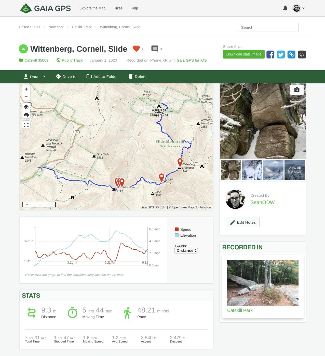
I also sometimes plot a route ahead of time on Gaia’s website to get a sense of what the total distance and elevation will be. This is very handy for planning multi-peak hikes that might have bushwhack sections. I take all these figures with a pinch of salt, but it’s nice to have an idea of what I’m getting into.
Adding Photos as Waypoints in GaiaGPS
Something I’ve just started doing recently, post-hike, is importing a few processed photos into my tracks as key waypoints. This is similar to marking waypoints on Avenza with pins, but even easier. Via the app or the website, you can select which images you want to upload to your account. Gaia then uses each photo’s embedded GPS info to place the image automatically. It uses the filename as a placeholder label, but that’s easy to change. Handily, these photo-waypoints show up in any tracks embedded on webpages.
Navigate Anywhere
Gaia offers its standard topographic map for free. It covers the entire globe, using a combination of proprietary data and OpenStreeMap data. The main Gaia topo layer recently underwent a redesign that made it even easier to read, and even more beautiful to look at. Contour lines appear sooner and more quickly, and the topography is now nicely shaded.
Gaia Account Levels
Gaia has three membership levels: free, member, and premium member. You can do everything described above with a free account. Becoming a paying member provides access to more map layers, the ability to download maps to use offline, and to print maps. Premium members get even more detailed maps layers to choose from, including US hunting maps.
The premium membership includes many wonderful National Geographic illustrated maps — but not all of them. It does not include the NatGeo illustrated maps for the Adirondacks. That was disappointing to learn after the fact. I’ve since dropped back down to the ordinary membership level.
CalTopo The 800lb gorilla
Quick Info: Venerable, powerful, and beloved — but also ugly and slow.
CalTopo gives you tools to plan your backcountry adventures including topographic maps and aerial imagery, slope angle shading, view-shed analysis, realtime SNOTEL and weather data, and many more options.
Similar to GaiaGPS, the app integrates seamlessly with a dedicated website.
I know many people swear by CalTopo and find it has great utility, especially for planning bushwhacks. For example, being able to shade the slope-angle means you can clearly see the steepest terrain, in fine detail, allowing you to navigate difficult ledge systems safely.
However…
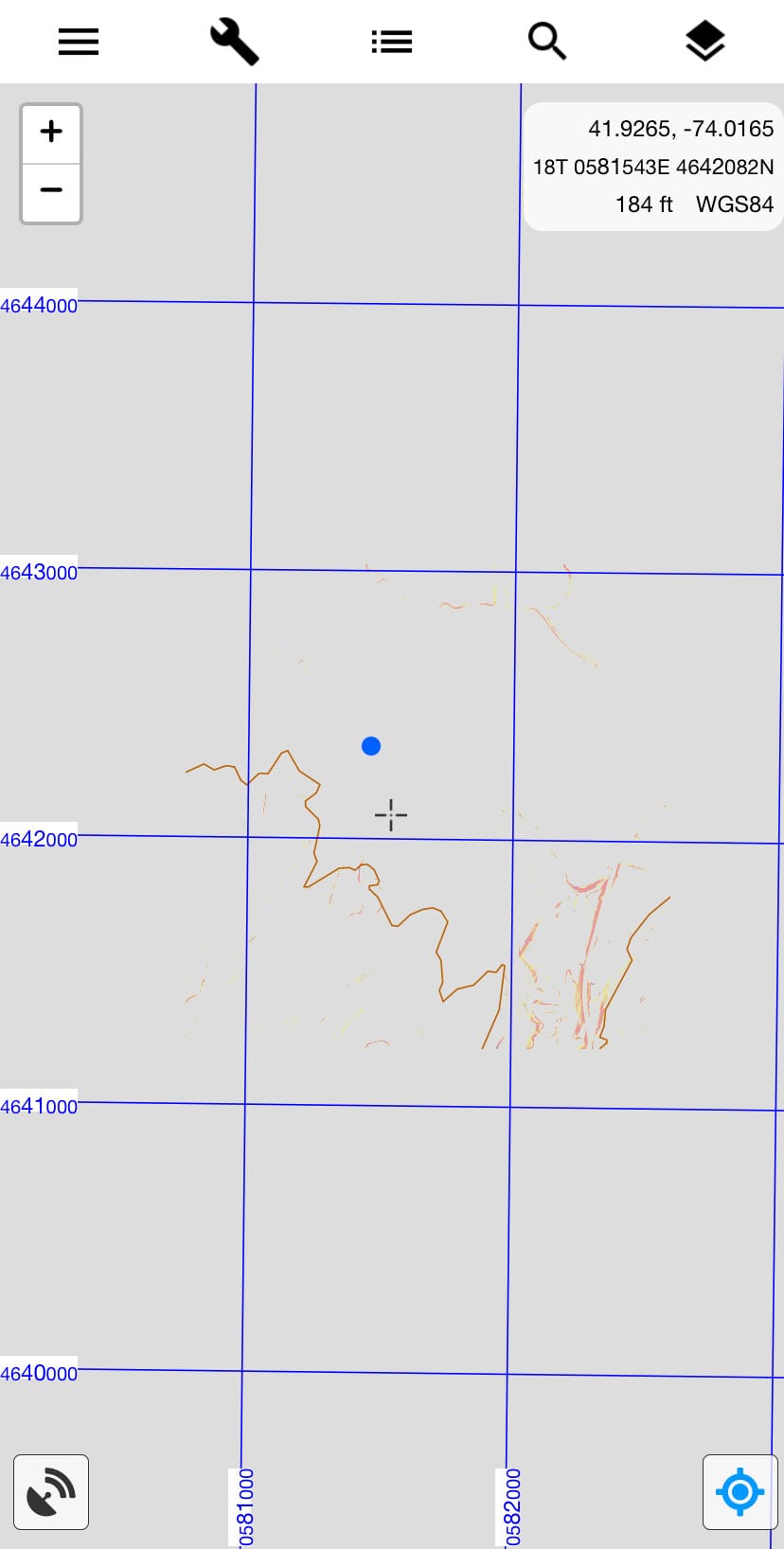
I don’t use CalTopo myself. Basically because, every time I load the app, it takes forever to load the intial map layer.
I just tried again while writing this post and the initial layer took several minutes to load, even on fast WiFi. See screenshot. It eventually loaded but, when I pinch/zoomed, the whole process started over.
I’m open to being set straight on this. Maybe I need to have a paid account to get faster download times…?
But this slowness has been my experience any time I’ve tried to test CalTopo. I include it only because it’s so well regarded. It’s used by search and rescue teams and first responders. I hope to learn more later…
AllTrails The Facebook of hiking
Quick Info: It may be the most popular outdoors app but it’s slow, and the crowdsourced trail intel can be sketchy.
If there’s one app on this list you’ve almost certainly heard of before — and probably already have on your phone — it’s AllTrails, the hamburger of hiking apps. Everybody knows it, everybody uses it, everybody loves it. It may not be “the best” but that may not be “the point”. It’s on almost every list of best hiking apps for a reason.
But I have some thoughts…
It looks great but I’m always bugged that it takes so long to open. In contrast, Gaia and Avenza open very quickly.
For most hikers on most hikes, I’m guessing, AllTrails works really well. Its database of trails is enormous and regularly updated with crowdsourced notes and recent intel. You can also record your track as you hike, and check for scenic views and points-of-interest which are marked on AllTrails’ topographic map. If you already have AllTrails in your toolbox, and it’s working well for you, fantastic!
My one concern is that, for mountain hikes, the quality of the crowdsourced intel is low. Many experienced Catskills hikers share this concern.
Mountain Hikes Need Additional Knowledge, Planning, and Gear
On mountains, the level of difficulty and the potential for danger are considerably jacked up. Even during the warm seasons, for example, the Devil’s Path regularly pops up on “hardest trails in America” type lists. In winter, multiply all concerns by ten.
If you’re used to using AllTrails, and have had good experiences with it, you may have a false sense of ease when it comes to planning a mountain hike.
AllTrails makes it easy for anyone to wander into the wilderness — but not everyone is fully prepared. Over-confidence and under-preparedness often leads to rescues. Sometimes that combination leads to recoveries.
There are lots of great sources of info for recent trail conditions and general intel from experienced mountain hikers. See the Trail Conditions widget on this page for some great links.
Please also make sure to check out the Wilderness Safety and Hiking Gear sections on this site, and elsewhere.
Check out this hiking and camping gear list.
Do your research. On a mountain, help is often many many hours away. Only you are responsible for your safety.
Google Maps All your pins on 3d terrain with great integration
Quick Info: Great for navigating to trailheads, handy for long term planning.
Because of Google’s cross-platforms dominance, the Google Maps app might be the fastest way to get driving directions from your location to a trailhead.
Personally, I use Apple’s mapping system. I like how well Apple Maps integrates with iCal where I block out my week. I’ll add an event for a hike and drop the trailhead address in the location field so that a) I get reminders to get going on time, b) I can estimate the drive time in iCal, and c) when I actually get in my car the driving directions pop up automatically.
But I know most people still prefer Google’s Maps app over Apple’s Maps app.
I mainly use Google Maps with terrain switched on for marking which peaks I’ve climbed, which peaks I want to climb, and special locations.
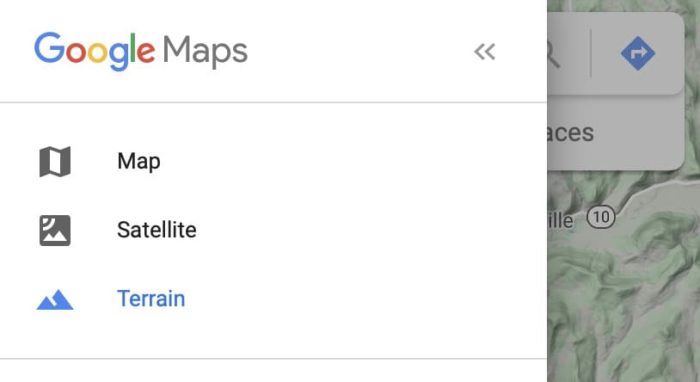
Google’s Awesome Terrain Layer
To turn on the terrain layer, click the hamburger icon top left. A panel opens up, and you can see the Terrain option in there…
I love this layer. The ease of moving between states and countries in a single system is a big draw. I want to knock out a bunch of Adirondack peaks in 2020, and I’ll also try to bag a few peaks in Ireland this summer. A few Whites and Greens, and the Knife Edge Ridge route to Katahdin, are also on my radar. Having all my peaks in one place really appeals to me.
Above you can see my bagged Catskills summits (squares), the restaurants and cafes (stars) on my list of best places to eat in the Catskills, and a few new locations I want to visit (flags).
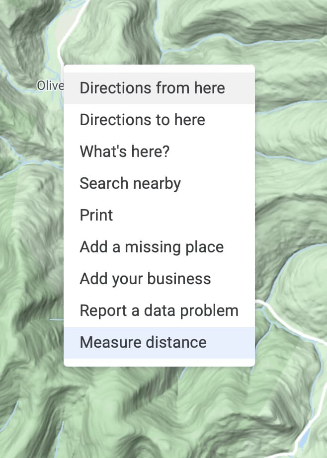
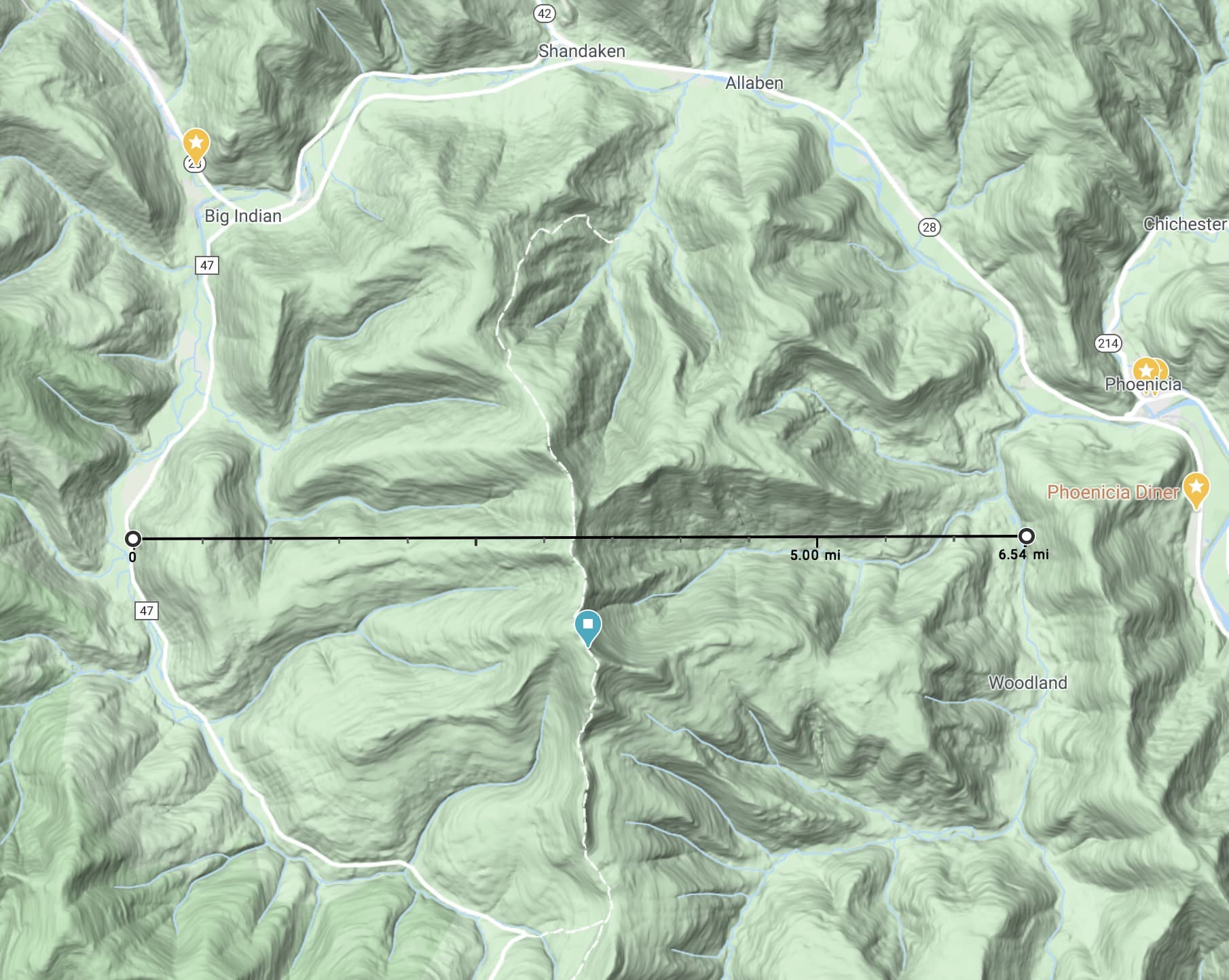
I also like being able to measure distances easily. Left/Ctrl click anywhere on the map to get this menu, with “Measure Distance” as the last option.
You can then measure from point to point, but also add as many points as you like. Note that all these distances are “as the crow flies“. They don’t take elevation into account, the way plotting a route on Gaia’s site does. But it’s nice to know that the impact crater around Panther Mountain is 6.5 miles (10.5k) wide, or that Indian Head, which is visible from the fire tower on Balsam Lake’s summit, is about 24 miles distant.
That’s all I use Google Maps for. It’s low-level but it does these simple things very well.
Best Hiking Apps: The Best Apps for Field Identification
PeakFinder AR Fast & Accurate Mountain Identification
Quick Info: The fastest augmented reality app for identifying summits.
I started with PeakFinder and loved it. Then I found PeakVisor and switched to it for a long time. I’ve subsequently switched back to PeakFinder as my go-to app. It’s not as pretty as PeakVisor but it loads and identifies so much faster. This is a theme with me. I really don’t want to stand around, especially in the winter, waiting for apps to do what they’re supposed to do. I really appreciate how PeakFinder is optimized for blazingly quick start-up and field identification. Both apps actually perform well. I’m just very impatient.
Augmented Reality FTW
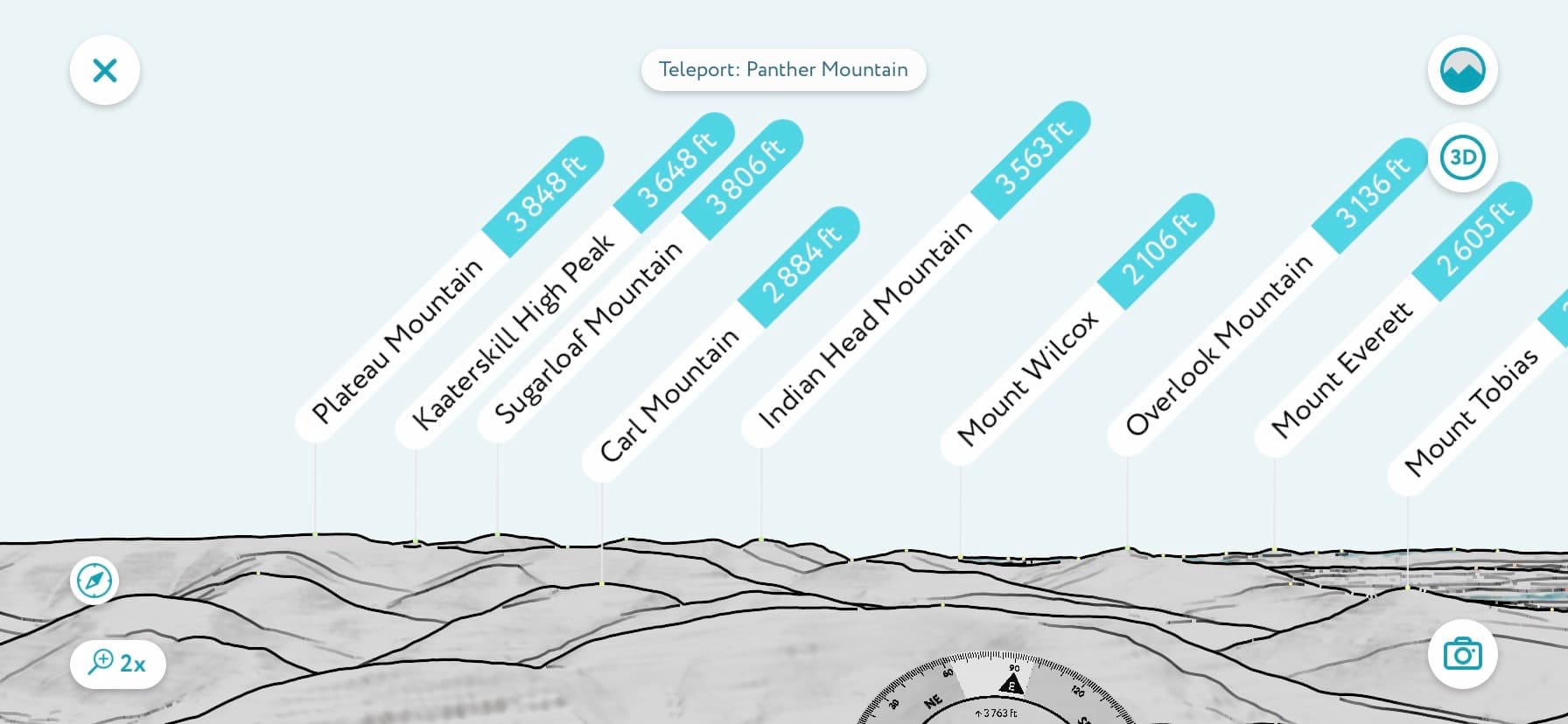
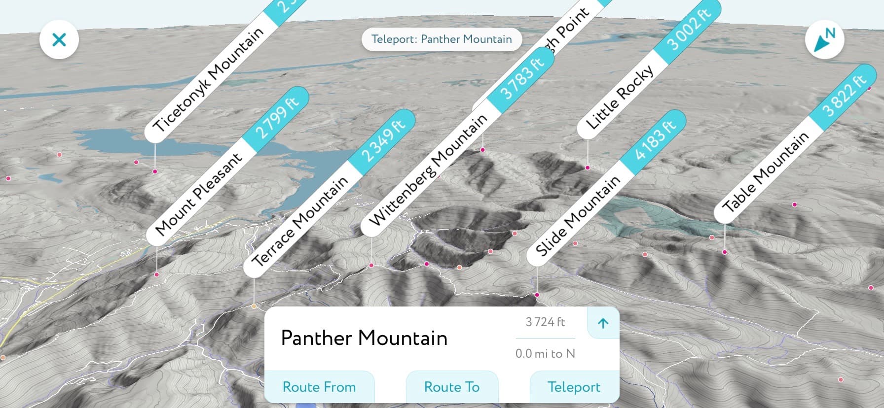
Here’s a screenshot of what you’ll see using PeakFinder from the top of Panther Mtn. Both apps allow you to point your camera in any direction and see the peaks immediately around you clearly labelled. Both apps also all you to make this view transparent so you can “see through” the screen while retaining the labels.
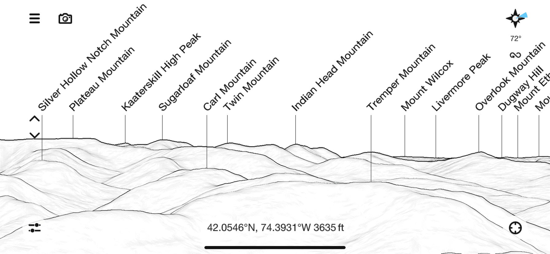
The arrows on the left allow you to launch your viewpoint well above your current elevation to get a clear bird’s eye view of the landscape surrounding you.
Sometimes you need to drag the labels into position but, once you’ve lined up the mountain outlines with the peaks you see in front of you, it’s a fantastic aid, especially for new views.
PeakFinder Options
The hamburger icon opens a menu with lots of additional options. Chief among these is the ability to “teleport” to any other peak in the database and see the view from that location. Super fun.
At first, I found this interface a little dull but I’ve lately come to appreciate its clean, minimal style. It’s far more intuitive and easier to use than PeakVisor’s interface which now feels over-complicated to me. PeakFinder is also several times faster at launching and at unpacking views. It just works better.
On a hike, I really want to fuss with my gear as little as possible. I take most of my photos in less than 15 seconds. I want a similarly zippy experience when using any app, whether it’s for navigation or identification. I’ll gladly sacrifice prettiness for more speed. PeakFinder scores higher here.
PeakVisor Prettier than PeakFinder but slow to load
Quick Info: This summit ID’ing app really pleases the eye.
I was immediately drawn to PeakVisor’s interface for design reasons. I prefer its large clear labels and multiple view mode options — but I’m not sure having the height on-screen adds a lot. It takes up a lot of screen real estate without adding real value. I don’t think there’s a way to hide that field but I wish I could. I just want to know what mountains I‘m looking at.
PeakVisor’s aerial view is superior to PeakFinder’s. The colors and labels really help features stand out, and I prefer the contoured/shaded look.
But speed is an issue for me. It may not be for you. PeakVisor certainly looks great and, overall, it works well. I would take parts of each of these apps and merge them into one super app. For now, they are both the best hiking apps for identifying summits.
Seek by iNaturalist Fantastic Photo Analysis for Flora/Fauna Identification
Quick Info: Identify plants and animals with image recognition technology.
Seek is great. As a super-curious know-nothing, I love it. It’s really helping me learn the flora of the Catskills. It analyses the photos you send it and identifies organisms based on matches to its vast database of insects, birds, plants, amphibians, and more. You can add your observations to its database of observations on iNaturalist.org, where images are automatically tagged and geolocated and added to a public map overlay.
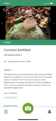
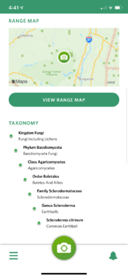
With each identification, Seek gives you some interesting information as well as the organism’s taxonomy, from Kingdom to Phylum to Class all the way down to Species. I haven’t done a deep dive into Seek or iNaturalist as I’ve been pretty delighted by simply learning about what I see around me.
I don’t do any identification in the field because I suspect Seek needs Internet access to do its thing. Instead, I process photos and send them to Seek from the comfort of my couch. This allows me to crop images closer to the subject, which gives Seek a better idea of what I’m trying to identify.
It’s not perfect, but it usually gives you at least a Family or Genus designation and some suggestions as to Species. It’s good enough to send your Google searches in the right direction.
Seek does not require registration and does not collect any user data by default.
Best Hiking Apps: Premier Photography Goodness
Adobe Lightroom Powerful Photo Editor
Quick Info: Lots of fine control, easy watermarking, and tons of storage.
As a designer, I got off the Adobe merry-go-round several years ago by switching to Affinity’s suite of apps. I came to hate Adobe’s bloat, its bugginess, and their monthly fees. But I have to say Lightroom works really well. It has great tools for tweaking lighting and colors, reducing noise, sharpening, correcting geometry, and so on.
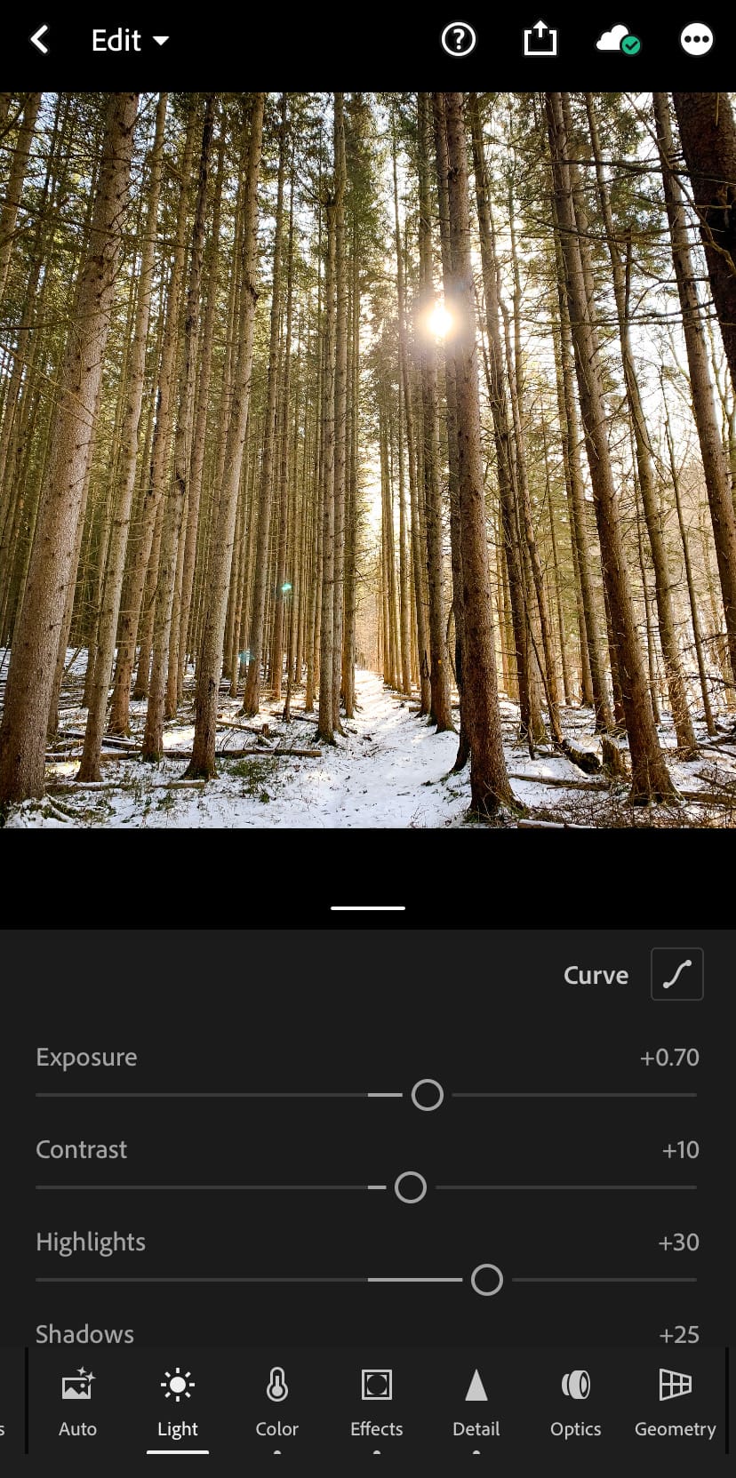
I do all my photo editing on my phone. Lightroom’s interface is very intuitive and, handily, it includes a series of easy-to-follow tutorials, so you can get up to speed quickly on its wide array of tools and options.
If you’re more into applying filters you might prefer VSCO, Snapseed, or even Instagram. But I prefer Lightroom because it gives me far more fine control.
The free version of Lightroom is very powerful. I used it for a long time. But recently I started paying the $4.99 a month for the full app and 1TB of storage.
The desktop app is an additional $10 a month. I haven’t felt the need for that as I already have Affinity Photo if I want to go that way — for example, if I pull in Camera RAW images from my DSLR, that’s how I process them initially before transferring them to Lightroom for deeper processing.
Instagram Powerful Community Finder/Builder
Quick Info: The best inspo, and the best way to build community around your photos.
Like all social media, Instagram can feel overwhelming while you climb its learning curve. Finding the right hashtags to use and to follow, experimenting with the best times to post your photos, learning how to use the Story function well, and so on.
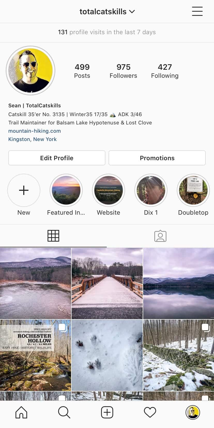
But once you get going you’ll soon start to see the same accounts popping up in your feed again and again, and everyone is glad to receive positive feedback on their posts. I’ve found the ’Gram super-useful for finding an audience for my mountain photos, and for building a network of knowledgeable friends.
Community Builder
I’m guessing, like Twitter, Instagram has numberless communities built around given topics. Hiking is certainly no exception: there are Catskills IGers, Adirondack IGers, White and Green Mountain IGers — all using hashtags to find each other’s content and make connections.
Here’s a selection of hashtags to get you started: #CatskillMountains #Catskill3500 #ForestBathing #GetOutAndHike #IGerCatskills #OptOutside #HikeNY #HikingLife #NYNJTC #VisitCatskills #PureADK.
And if you ever need a quick jolt of rando inspo, the main #Hiking hashtag currently has 52 million images for you to scroll through. Instagram really is one of the best hiking apps!
Instagram Layout Apps
It’s crazy that Instagram doesn’t include some basic layout options for combining photos. Even crazier? No one app fills the gap. Instead, you have to combine apps to cover the various options. I love you, Instagram, but get it together man!
Square No Crop for Instagram
Square No Crop lets you post taller photos than IG normally allows by adding white space.
Grid Post
I use Grid Post to cut wide images into seamless, swipe-able Instagram panoramas.
Layout from Instagram
Finally, Layout allows you to combine several images in a variety of layouts you can select from an array of templates.
Best Hiking Apps: Pure Phone Fun
Maps 3d Pro Project Your Hike in Three Dimensions
Quick Info: I literally use this app for doing one thing, but it does that one thing very well.
The blurb for this app says you can use it for planning but I dunno. Its interface needs a design refresh and the app seems like a closed system. However, it plots your GPS track over a 3d projection of whatever terrain you hiked, and you can then pinch/zoom and twist your way around the landscape. It’s great fun.
I love classic topographic maps but being able to see landforms and tracks in three dimensions makes the experience far more accessible. If GaiaGPS had 3D projection, it would be killer. Until it does, we have Maps 3D Pro. For this function alone, I think it’s one of the best hiking apps.
SkyView: Explore the Universe Easy to Use in the Field with Super-Clear Graphics
Quick Info: Just point your iPhone at the sky to identify stars, constellations, planets, satellites, etc.
There are so many astronomy apps to choose from. I like this one because it works so well. The interface is never fussy or fiddly, and stays out of the way until you need it.
Sometimes, you just want to know what an object is. Recently, coming down Daley Ridge, a very bright object high in the sky kept me company. I couldn’t decide if it was Venus or Jupiter. I didn’t have SkyView on my phone at the time so, when I got home, I oriented myself to face southwest and confirmed it was Venus in one of its unusually wide orbital positions.
SkyView identifies constellations and individual objects like stars and planets, of course, but also satellites, comets and asteroids. I like the overlay showing an object’s path across the night sky until the current moment, and then continuing (as a broken line) for the remainder of the night. There‘s also a night-mode which turns the interface red, so checking the app won’t ruin your dark-adapted night vision.

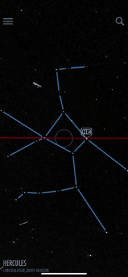
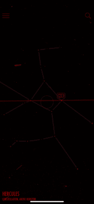
Overall, this app couldn’t be simpler to use. It’s super intuitive. A definite keeper.
5 More Fantastic Hiking Apps
I have to end this article some time, but it could easily go on and on. There are so many great outdoors apps. Here are five that didn’t make it onto the main list of best hiking apps but have popped up on my radar for one reason or another.
I haven’t used them much so I can’t recommend them from any depth of experience, but they look useful and I’m currently testing them out.
These Might Also Be The Best Hiking Apps — For You!
- Cairn — Crowdsourced cell coverage maps and live tracking/alerts so your friends can see your GPS location and get an SMS if you’re not back in time. There’s a monthly/yearly fee but this app looks great. Currently testing.
- REI Guide to National Parks — the Catskills and the Adirondacks are State Parks so they’re not listed here but this app has a ton of daydream inspo content and sweet maps to pinch and zoom.
- REI Hiking Project — However, this REI app does have all the major Catskills trails and promises curated highlights from knowledgable trail hounds. Currently testing.
- onX Hunt — Paid app for hunters with maps that show all property boundaries. Well-regarded by the hunting community. I don’t hunt but I spent a very interesting 30 minutes playing with this.
- GutHook — Beloved app I need to dig into more. It’s geared toward long backpacking hiking trails like the Appalachian Trail, the PCT, CDT and the John Muir Trail. But I can see a time when it’s part of my regular kit and it will definitely come in handy when I start hiking further afield…
Next…
Okay, so you’ve read about the best hiking apps. Now grab a list of the best places to eat in the Catskills.
I hope these apps make your next hike even more enjoyable. Several of them — like Avenza, GaiaGPS, and PeakFinder — should be a part of your basic hiking kit. (But never rely on apps as your only source of navigation! Read up on wilderness safety.)
Get full access…
Get instant access to the full version of this site and enjoy great supporter benefits: full galleries, full trail notes, early access to the latest content, and more.
Hot on the website right now…
Follow for more…
Follow my @TotalCatskills content on Instagram for regular hiking inspo and safe, inclusive community.

With all due respect, I gotta disagree with you about Alltrails – not about how problematic it is – it’s 🍌 🍌 problematic! That’s why I believe it is ESSENTIAL! That trail with 472 reviews posted in the last month? Nope. That trail with an average rating of 2 stars from 47 reviews total, 42 of which are a variation on the “After walking in MUD around TWO fallen trees in the MIDDLE of the trail I HAD TO turn back at just 1/4 mi! NY DEC should REALLY do something about this!” theme? Welp, trail #2 is just begging for further research!
All joking aside, I fully support a full spectrum of trail types to accommodate the full spectrum of people types. If you know you’re fully on either extreme of the spectrum, Alltrails is unrivaled for easy, fast elimination. I’m full of it, yes, but I fully stand behind my Alltrails opinion. 😇
Fantastic post. Fantastic blog😍
LOL. There’s a meme going around at the moment speaking to how betrayed people can feel by AllTrails when they actually get to a trail. Someone will write “this trail was easy!“ but when you get there it’s 5000 feet of elevation gain on sketchy rock scrambles and a swamp swallows your dog. 😂
Great info. Fully comprehensive. Thanks for all the legwork. This is EXACTLY the information I was looking for. You’ve left no stone unturned! I’m looking forward to more.
Glad you found it useful, Robert! 👍