
Disclosure: This content may contain affiliate links. Read my disclosure policy.
A tricky long out-and-back route. You’ll need to pay attention.
The Mount Marcy hike via the Van Hoevenberg Trail is not a casual hike in the Adirondacks. At roughly 15 miles round trip with about 3,600 feet of elevation gain, this is a big day in the High Peaks. Not brutally technical, but undeniably demanding—and, my word, so totally worth the effort.
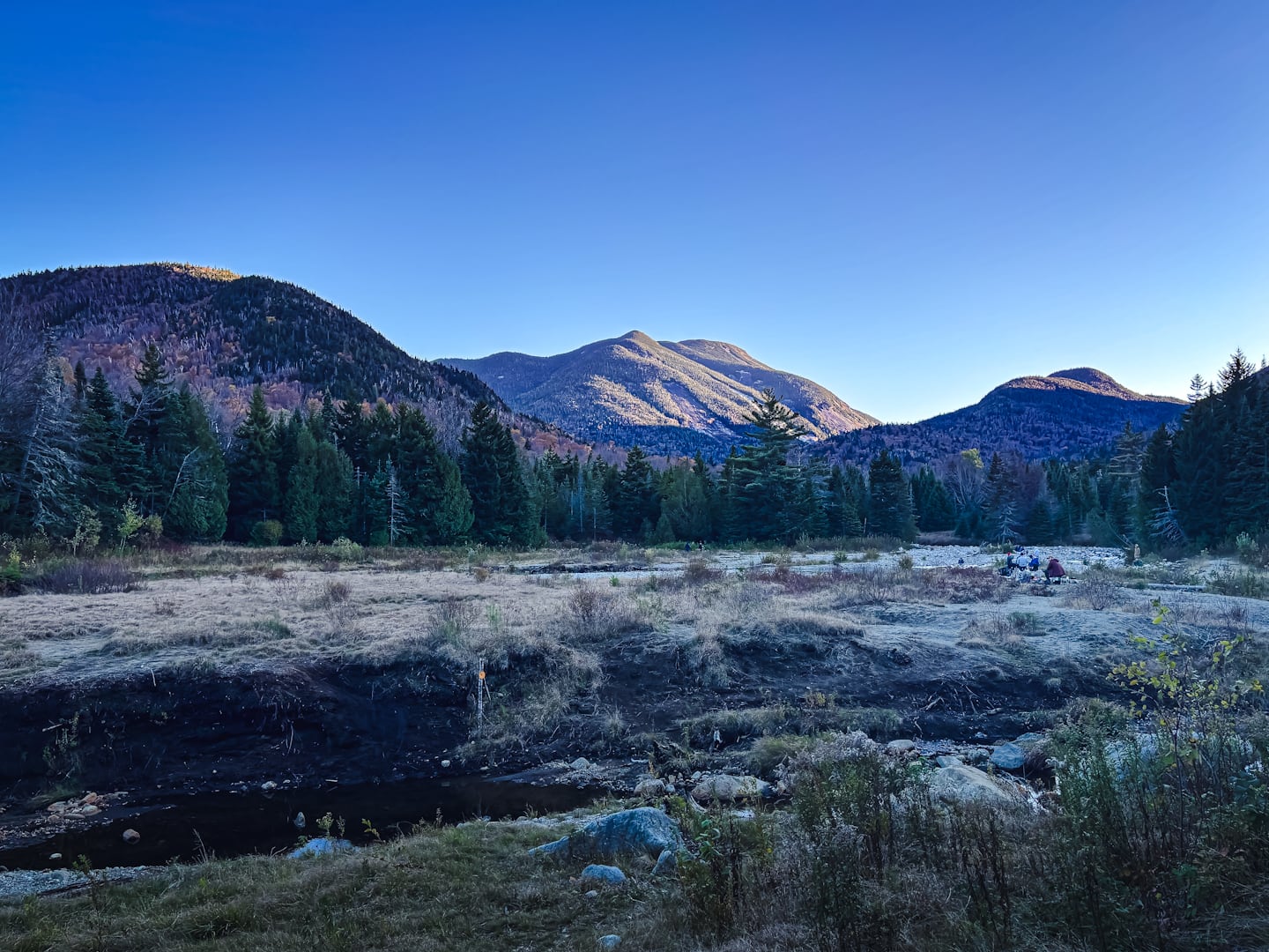
This route pulls you deep into Adirondack backcountry before it starts climbing. You’ll move through long stretches of forest, cross streams, and pass a steady sequence of trail junctions where it’s easy to drift off-route if you’re not paying attention. This isn’t a hike you can do on autopilot, especially on the way out, when fatigue has a say in your decisions.
But then, suddenly, you’re above it all. Marcy’s summit is broad and exposed, with sweeping, uninterrupted 360° views that feel earned in a way few hikes deliver. The surrounding High Peaks roll out in every direction. On a clear day, it’s one of the most expansive vistas in the Northeast. You’ll see so many of the high peaks you’ve already hike, or will soon hike, some up close and personal, and more that look like they’re a thousand miles distant.
There’s a very fine satisfaction in standing on the highest point in New York State. Not just for the banger views, but for the sheer effort it took to get there. Marcy doesn’t give itself to you easily but, if you come prepared and stay steady, this Mount Marcy hike gives you a day you’ll remember for a very long time.
Frequently Asked Questions
How long does it take to hike Mount Marcy?
Allow 8-11 hours for this hike, depending on your very personal legs.
What is the elevation gain for the Mount Marcy hike?
The elevation gain for this hike is 3,600 feet (apx 1,100 meters).
Mount Marcy Hike Trail Guide
The Mount Marcy hiking trail includes…
- A very long hike in
- A steady and wearing climb
- Wonderful trails and scenery
- Many junctions a.k.a. opportunities to get off course
- Visual drama at many points
- Incredible summit with incredible views
- A long hike out!
A full breakdown is provided below in the hike notes with lots of photos.
BTW, you might also enjoy…
- NEW › Winter Skincare for Hikers
- CATSKILLS › Best Catskills Waterfalls
- STAY › Find Your Perfect Catskills Stay
- ADIRONDACKS › Hike Van Hovenberg
- ENTERTAINMENT › Best & Worst Hiking Movies
- Follow › My Instagram @TotalCatskills
- Follow › My Substack @TotalCatskills
- Follow › My writing for Times Union
Mount Marcy Hike Notes & Gallery
You’ll need to park at the High Peaks Information Center to begin this hike. That requires getting there before dawn, once the hiking season heats up. There is literally no way to get here too early. The enormous lots fill up very very early.
Make your way out to Marcy Dam, the first big views of the day. You’ll see Mount Colden and Avalanche Mountain in the distance…
Your next target is the junction with Phelps…
You’ve got the basic details, but there’s so much more…
Unlock this exclusive content to get deep intel on this hike, including my personal tips. Immerse yourself in every layer of the journey. With Mountain-Hiking.com, you’re not just skimming the surface; you’re delving into a passionate hiker’s in-depth experience.
Become a Patreon supporter today and immediately elevate your hiking adventures with full trail beta, comprehensive insights, and stunning visuals. Experience hundreds of trails to their absolute fullest!

Similar to this Mount Marcy Hike
This is a long Adirondack hike! Similar-ish to tackling the Dix Range or the Santanoni Range.
Read More
Get full access…
Get instant access to the full version of this site and enjoy great supporter benefits: full galleries, full trail notes, early access to the latest content, and more.
Hot on the website right now…
Follow for more…
Follow my @TotalCatskills content on Instagram for regular hiking inspo and safe, inclusive community.
Mount Marcy Hike via Van Hoevenberg Trail Trailhead
Central parking for the ADK high peaks. Fee. Incredibly popular lot. Get there well early, long before dawn in peak hiking weather.
Google Maps Location: 44.183070, -73.964309
The map below shows the exact topographic location of the trailhead
Cell Service
Good up high. Forget about it down low. My network is Verizon. YMMV.
The parent mountain for this hike is Mount Marcy.
