Disclosure: This content may contain affiliate links. Read my disclosure policy.
For general reference only, not for navigation.
Trailhead info at bottom of this post.
Hiking Trail Description
Without question, hiking Rocky and Lone is by far the toughest mandatory Catskill 3500 hike. Both mountains are extremely difficult. They are untrailed and very rugged. More importantly, they are remote. Before you begin your ascent of either peak, you face a long hike in, either over other mountains first, or via the long and treacherous Fisherman’s Path.
Rocky in particular is a super challenging mountain. It’s the most arduous 3500 mountain to even get to. It’s steep and… well… rocky. Down low, it’s rugged. Up high, it’s riddled with confusing herd paths. And the forest all around its summit is so dense that hikers need to take physical precautions to prevent damage to their skin and eyes.
After a long hike, you might really enjoy tapping the 10 Best Post-Hike Hacks.
Even though I’d been through the terrain once before, and have good nav skills, I was apprehensive to solo hike Rocky and Lone. I saw it as a personal challenge. It felt like something I wanted to prove to myself, for myself, that I could do by myself. I took it seriously enough that, in fact, that I put off doing it for a long time. I waited until I felt really ready to tackle it. In the end, I got it done — but I did not ace it.
I do not recommend that anyone hike these mountains alone.
The only truly safe way to tackle Rocky and Lone is with a guide — either a licensed guide, or as part of a group hike led by a reputable hike leader. Keep an eye on the Catskill 3500 Club group hike schedule to see when their next Rocky/Lone hike is scheduled. Their hikes fill up quickly, so jump on any open spots immediately. They have a weekly email blast you can sign up for.
Trailhead Parking
This part of the Catskill Park is a popular destination. The DEC lot in Denning is pretty busy most weekends. In summer, even during the week, it’s very busy; many weekend hikers overnight along the Fisherman’s Path and the hike to Table and Peekamoose from Denning is really lovely. I arrived at the lot on a Friday morning, and it was mostly empty. By the time I got back, it was mostly full, packed almost to capacity with the cars of weekend campers.
Rocky and Lone Hiking Route
Warning! Cell service in Denning and all along the Fisherman’s Path is non-existent. Zero service. The summits of Rocky and Lone do have some signal but you should plan on having no service for 99.9% of this hike.
There are three main ways to get to Rocky: by hiking in from the east over Balsam Cap, by coming in from the west over Table and Lone, or by hiking along the East Branch Neversink via the Fisherman’s Path, a dubious but very popular and beautiful unmarked herd path.
For this hike, the latter is the route I took. You can read about that portion of the hike in detail at Fisherman’s Path.
The rest of this post takes up the hike from where that post ends.
Decision Time
The Fisherman’s Path terminates at the mouth of the rugged drainage that runs down from between Rocky and Lone. Currently, a massive blowdown marks the terminus. The photo below shows a piece of it — you’re looking across the drainage and into the woods beyond.

From here, I poked around briefly on the far side. I wanted to see if the herd path continued uphill any distance, but it fizzled out quickly.
Ralph Bressler at CatskillHiker shows a route up Rocky that uses the ridge which he describes as very steep in spots and quite tough. I was curious about that route. But I also wondered about climbing the drainage, as I’ve done that a few times and don’t find drainages too difficult. They have the advantage of not having to push through dense trees and hobblebush. They also have the disadvantages of being wet, mossy, slippery, ankle-twister terrain.
For the sake of having a different route described on the Internet, I decided to climb the drainage. I figured it would also be a good way to get up the herd paths without getting too scratched up. I was mostly right.
Ascent via the Rocky and Lone Drainage
A faint herd path marks the start of the drainage. Aha! I thought, I‘m not the only one to attempt this route. But once again, the trail evaporated quickly. I soon found out why.

The drainage was easy enough at first, but immensely wet — not just in the bouldery middle, but on both sides. I stayed mostly on the left side, where water seems to pour down off Rocky’s northwestern ridge constantly. It was swampy in spots. There was some hobblebush to work through, which is always tiring. The going was slow.

Soon enough, however, I was able to turn around and see Slide Mountain towering above me. At 3487’, Rocky is the lowest of the Catskill High Peaks. At 4184’, Slide is the tallest. From low down on this drainage, this vantage point really emphasizes their difference in height.
The drainage sides quickly funneled me deeper into the middle — it just became too steep and too sketchy to hang on to the edge, so I moved down into the rocky part and began picking my way upstream through the boulders.
Warning! Reminder that this is not a route description. This is a bushwhack report. There is no route.
All along the drainage, there are multiple feeder gullies. Some are great gashes in the side of Rocky’s ridge, very dramatic and intense-looking boulder-filled chasms. At one point, I thought about climbing out of the drainage via one of them but decided no way.
As you climb drainages, they split into smaller and smaller channels, offering an increasing number of possible routes the higher you go. Your best guess is always just that, a guess.
The first choice I had to make, at 2920’, was at a simple fork. I looked at the configuration and tried to figure out which side would be best: left or right. I chose right.

The next choice, just below 3000’, was an irregular trident, offering a choice between left/middle/right. This split is more or less exactly where, on NYNJTC maps, the blue line denoting the brook ends. I picked middle and moved on.
Higher up, the drainage heads toward the middle of the col, tracking too far west for the day’s purposes. At around 3100’, I left the drainage and began to head east/left through the bare hobblebush and fallen ash leaves.
Again, slow going.
Rocky’s Dense Forest
Just below 3200’, I started to skirt Rocky’s infamously thick forest. Lots of moss, too.
The landscape really begins to change.


Near the col, things finally get less steep. Phew.
Eventually, you have no choice but to enter the woods. It’s not too bad — at first.


Somewhere around 3240’ elevation, on the north side of the col, I feel like should have found a herd path. My plan was to pick one up and head east to Rocky’s summit. But by now I was deep in the thickest part of the forest. In spots, it’s so dense, I had to don my safety goggles and push my way through pine branches. Feels terrible but at least it smells great.
I have no photos from this section. The hiking was too much work and, anyway, whatever photos I might have taken would’ve been 100% blurry pine branches.
Open Blowdown
I overshot the route I’d hiked before (and hoped to pick up again) by about 500 ft perpendicular, ending up more toward the center of the col.
The north side of this col is much less densely wooded than its south side, which is vexingly dense.
If you can, stick to the north side of the col.
Finally and suddenly, I found myself in large open patch of blowdown.

This open patch is at 3300’ / GPS 41.96898 N, -74.38088 W.
From here the going is much easier.
I was able to pick up the herd paths and follow them more or less consistently to the summit.
Herd Paths
Up here, there are no trail markings or reliable handrails. There are many herd paths, many routes to Rocky’s summit. A herd path here is as likely to end abruptly as it is to lead you somewhere useful.
The trails are often very clear, but sometimes very faint, and sometimes you just have to wander around until you re-connect with something — which might be the trail you were on, but might be another one…

There were a few spots that confounded me for a minute, until I was able to figure out where the herd path had disappeared into the trees only to pop out the far side.
I definitely checked my phone a few times to get a bearing and keep myself more or less on track. (Hiking snobs be damned. Up here, I’ve watched very experienced hike leaders do the same.)
The contours from the col to the summit don’t look like much, but there’s definitely still plenty of uphill to challenge your leg muscles.
The terrain is lovely. This part of the hike was my favorite: you’re beyond the dense firs, and into more open evergreen stands, with moss and soft pine-bed underfoot.

Somewhere in the middle of all this, I found a small lone maple tree, its bright golden leaves having fallen straight down and collected around its trunk like a garland. It was almost hallucinatory. I didn’t make a note of its location. If you ever find it, take a GPS reading and LMK!
Closer to the summit, there are a few small, easy ledges.
Along the way, you might think a number of times, “This is it!” This is not it. Keep going.
Rocky’s Canister & Scenic View
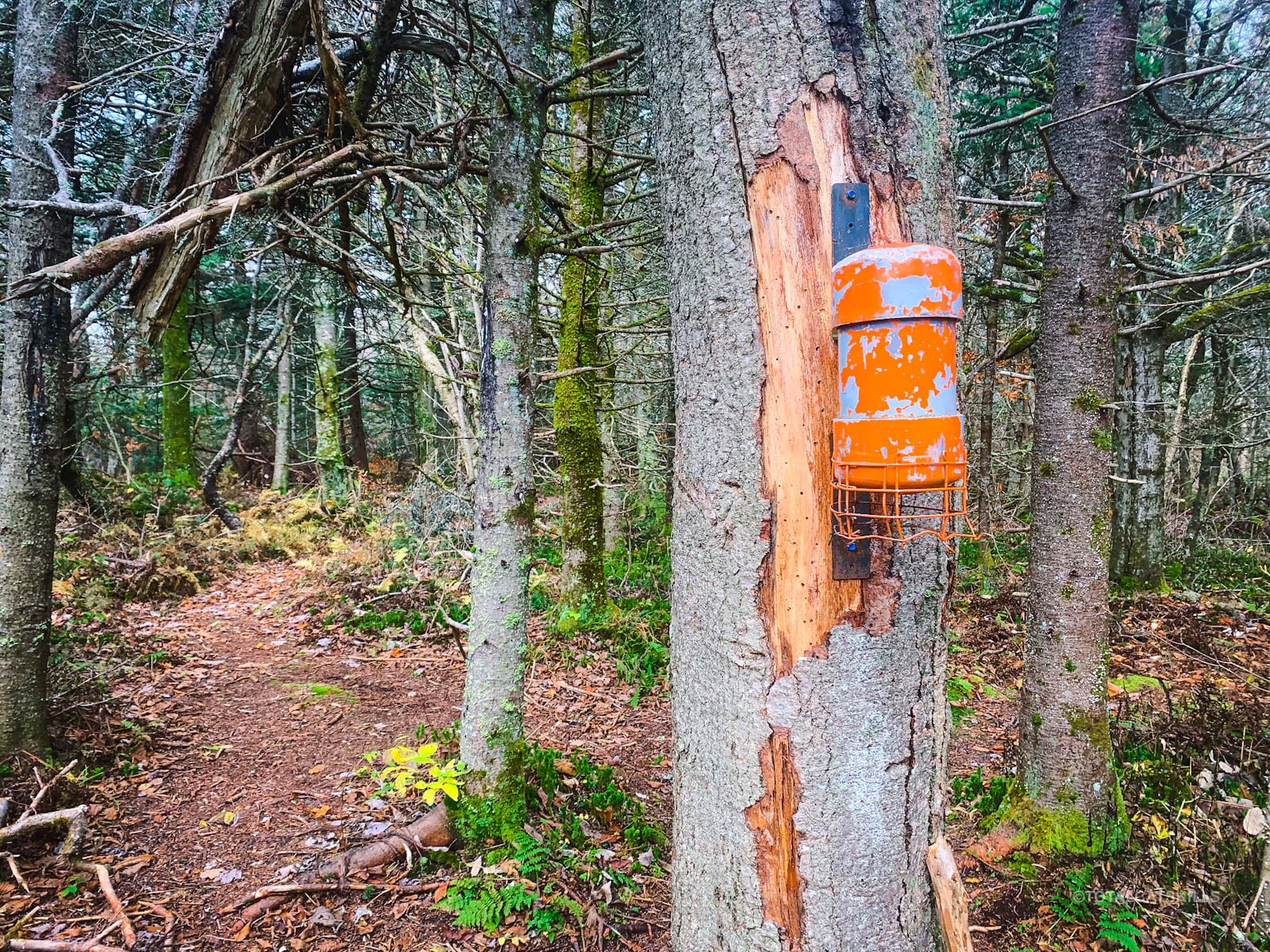
Eventually, you’ll come to the final boss: a small rocky nub. The canister is currently bright orange and quite visible. As you approach from the west, it’s on the left side of the herd path.

By this point, I was already feeling beat. I signed into the canister and sat down for a few minutes to eat lunch, and to let my legs recover.
There was a decent LTE signal at the summit. I was able to get a few texts out to my wife to let her know I was doing okay.

About a 125 feet east of the canister is a scenic view. From the canister, you can just about make out the rocky opening. If you approach the opening directly, you’ll have to climb over some hefty blowdown to get to the view. However, if you track a little to the left you’ll find a short spur that will give you access without drama.
You can see some of the blowdown in this video…
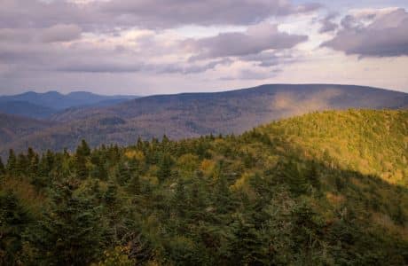
The view itself is solid. To the southeast you see the back side of Balsam Cap, but also Ashokan High Point, Mombaccus and Little Rocky.

Be very careful here. The viewpoint is actually the top of a sheer cliff…
There are several other herd paths in the area. I’ve read there’s a second scenic view close by, to the northeast, apx. 200 ft down a herd path. I did not look for it this time. Next time.
I started to re-think the rest of my hike. Head over to Table as initially planned? Or just get over to Lone and then head straight down to the Fisherman’s Path? I figured I would know the answer by the time I got to Lone.
Hiking between Rocky and Lone
I packed up and headed down the way I came, following the herd path I’d come up — until, almost immediately, I diverged from my previous route. After a minute, I realized I’d taken a different branch. All good.
As the crow flies, it’s less than a mile from Rocky’s summit to Lone’s. But the terrain is tough, and the near side of Lone is very steep. It definitely takes a while.
At Rocky’s summit, you could set a bearing of 256° minus 13° magnetic declination = 243° and use that as a rough guide for your direction.
Warning! Reminder that this is not a route description. This is a bushwhack report. There is no route.
Heading to Lone, my plan was to stick to the less dense north side of the col. This is the less dense part…

A strong herd path is emerging on the north side of the col between Rocky and Lone. It’s patchy but quite followable. It will be very clear to you. Until it’s not. Keep your bearing and forge ahead.

I lost and re-found the herd path several times. The hiking was pretty easy going until the uphill climb began to wear me down. I took lots of breaks. Candy was my friend.
I had to work around this fantastic rock wall…

The higher you get, the rockier and mossier Lone becomes. Just deeply satisfying Catskills vibes.


It also gets quite steep…

On the other hand, as you climb, a few moderate views begin to open up behind you.
After a particularly steep and rugged section, I popped onto a very clear herd path which led me directly to the canister. It reminded me of the herd path on Friday Mountain between the Pregnant Tree and Balsam Cap; it was that worn-in.
Once again, the canister is bright orange and extremely visible. I had no trouble finding either canister — exactly why they’re painted orange.


Again there was good LTE signal at the summit for sending out a text or two. As always, YMMV.
Lone’s Scenic View
I did not look for Lone’s scenic view. By this point, I was in conserve energy mode. However, I believe the scenic view is down the herd path to the south/left. That is, if you’re looking at the canister from the direction you arrived, there’s a herd path on the left. It’s quite clear.
If you find the view, let me know below.
The Hike Out
After resting, I decided I did not have another mountain climb in me. I scotched the idea of hiking to Table. Instead, I decided to head down Lone’s northwest ridge. I texted my wife about my change of route.
As it happens, it’s a lovely route. The herd path along the way is mostly very clear.
About 200 ft from the canister, you might come to a fork. If you want to go to Table, head left (southwest). If you want to descend directly to the Fisherman’s Path, turn right (northwest).
The trail descends beautifully.
Lone’s northwest ridge is magical, filled with strange, grassy patches and dotted here and there with stunted, creepy trees.


The route down is easy and lovely…

It was all going so well…
The Problems Begin
A little more than half-a-mile from the canister, at about 3100’, I lost the herd path — this time for good. I’d lost it a few times before and, each time, I’d just forged ahead and re-connected with it.
At this point, I should have doubled-back. Did I double-back? Reader, I did not double-back.
Instead, I remembered a route down this side of the mountain I’d seen online that reconnected with the Fisherman’s Path about midway along its length. For dumb reasons, probably for tired reasons, that is what I decided to do.
I began hiking directly north, moving away from the ridge line and, instead, heading down the very steep slope of Lone’s northwest ridge.
It was very steep. And very rugged, full of loose rock, wet dirt, and slippery duff. I had to be so careful.
My pace slowed to what felt like a crawl.
I also started to get very intense cramps in my right leg. Not fun.
This part of the hike was starting to suck.
I do not recommend this way down at all. Instead, you should follow the ridge line, keeping to the herd path until wherever it fizzles out. The embedded GPS route above shows a very rough indication. If you lose the herd path, double back until you find it again!
Anyway, after 30 minutes of nonsense hiking, I made it down to the Fisherman’s Path. I swear those 30 minutes felt like two hours. But now at least I was able to start hiking back along the banks of the Neversink.
By this time, however, the light was starting to fade. Basically, a number of mistakes I’d made during the day were beginning to compound and catch up with me.
One was losing too many electrolytes. You can’t stop yourself from sweating, but you can replace lost electrolytes easily. Pity I’d forgotten to pack any.
This was potentially the most serious mistake of the day because, walking along the Fisherman’s Path in the dusk, I now began to get bad cramps in both legs.
I normally don’t get cramps at all, but these were severe. Both hamstrings went into full spasm. Much, much painful. I had moments where I thought I might be camping out for the night. Luckily, simply waiting it out seemed to help. After a few minutes’ rest, and some water, the cramps subsided a bit and I was able to continue.
Hiking the Fisherman’s Path in the dark with intermittent cramping in both legs? Not fun.
The last 20 minutes before I got back to blazed trail were done in pitch dark. All around me at least, on both sides, I could see dozens of headlamps bobbing — campers setting up for the night.
And this last section also, at least, has the advantage of being the most worn-in. The “trail” is mostly very easy to follow, even in the dark.
Still, I was very glad to make it back to the big Neversink footbridge and reconnect with a blazed trail. I sat on the bridge for a few minutes to give my legs another rest.
From there, the 40-minute hike out to the Denning parking area was a cinch.

Mistakes I Made While Hiking Rocky and Lone
No hike is perfect but, on this hike, I fell victim to a number of questionable oversights. It might be instructive to review them…
- The Late Start. I got to the trailhead at 10:30am. This is very late to be starting a long, tough hike in October. My original plan was to hike out via Lone and Table, which would have meant getting back on blazed trail much earlier. I knew I’d be hiking out in the dark, so that was fine. As it worked out, though, my plans changed — and I’d left no contingency for such a change.
- The Wrong Gear. Not a big deal but I forgot to wear a long-sleeved teeshirt for dealing with Rocky’s fir forest. Top Tip: wearing long sleeves in those woods really helps reduce the number of scratches your arms pick up. At least I remembered to bring my safety goggles.
- The Under-Hydration. I simply didn’t drink enough, or often enough, during this hike. When I got home, my urine was crazy dark. Yikes. Lesson learned.
- The Electrolyte Loss. On long, hot or especially tough hikes, I normally bring a small bottle of Gatorade. It really helps. However, on this day, which was quite a warm day for October, I forgot to pack one. I definitely paid the price for this oversight.
- The Stubbornness. Not usually an issue with me, so tiredness was probably a factor. When I lost the herd path coming down Lone, I really should have reversed course. I’d have saved a bunch of time and stress.
Hike Planning & Execution
I hope these two hike reports together help you get a good feel for this hike and the terrain it covers — as well as underscoring the necessity of solid planning and execution that hiking Rocky and Lone requires.
The Fisherman’s Path is superb fun, but for my next visit to Rocky I think I’ll head out over Lone via Table. This means climbing Lone twice. There are no easy routes to Rocky mountain.
Rocky and Lone: Similar Hikes
A great way to experience this hike safely is as part of a group. See The Six: Friday, Balsam Cap, Rocky, Lone, Table & Peekamoose.
Another very tough Catskill hike is the bushwhack up Van Wyck and over to Table.
After a long hike, you might really enjoy tapping the 10 Best Post-Hike Hacks.
Rocky and Lone via Fisherman’s Path Trailhead
Large but popular, busy lot.
Google Maps Location: 41.964913, -74.452577
The map below shows the exact topographic location of the trailhead
Cell Service
Non-existent below the ridge line but both summits had good LTE signals. I was able to get texts out. Surprisingly, the northwest slope of Lone also had 3G for a fair while below the summit. My network is Verizon. YMMV.
4 responses to “Rocky and Lone via Fisherman’s Path”
Your comments are welcome here…
The parent mountain for this hike is Rocky.

I did this solo hike in September, hiking up Table and folowing the water divide line (NY/NJ TC map) to Lone. From Lone I went a little west of the divide, that was a mistake. I got tangled up in the balsams. I was later informed that an easier route is east of the divide to Rocky I spent the night on Rocky and bushwacked down to Fishermans path down between the drainages. The Fisherman’s path seemed to switch sides of the river. It was a long hike out, but there were at least two beautiful swimming holes back there.
Very cool to overnight in there. That is some remote sleeping! // Yes, I did a bunch of back and forth on the banks of the Neversink. Looking forward to revisiting.
Any advice on where to camp on a 2-day trip through Neversink to Lone, Table and back out on the loop?
There are lots of unofficial campsites along the western end of the Fisherman’s Path. Some look like they are not far enough from the water’s edge, so try to find one that is and follow the 150’ rule.