Disclosure: This content may contain affiliate links. Read my disclosure policy.
This tough AF thru hike requires a car at both ends.
Trailhead info at bottom of this post.
Hiking Trail Description
The Eastern Devil’s Path is one of the top Catskills hiking challenges. Traversing Indian Head, Twin, Sugarloaf and Plateau mountains, this is the toughest half of one of the toughest trails in the United States.
At close to 12 miles, and with just under 5,000 feet of elevation gain and loss, this challenging day hike includes stunning forests, extremely rugged trails and superb rock scrambles, as well as some of the Catskills’ finest boreal summits.
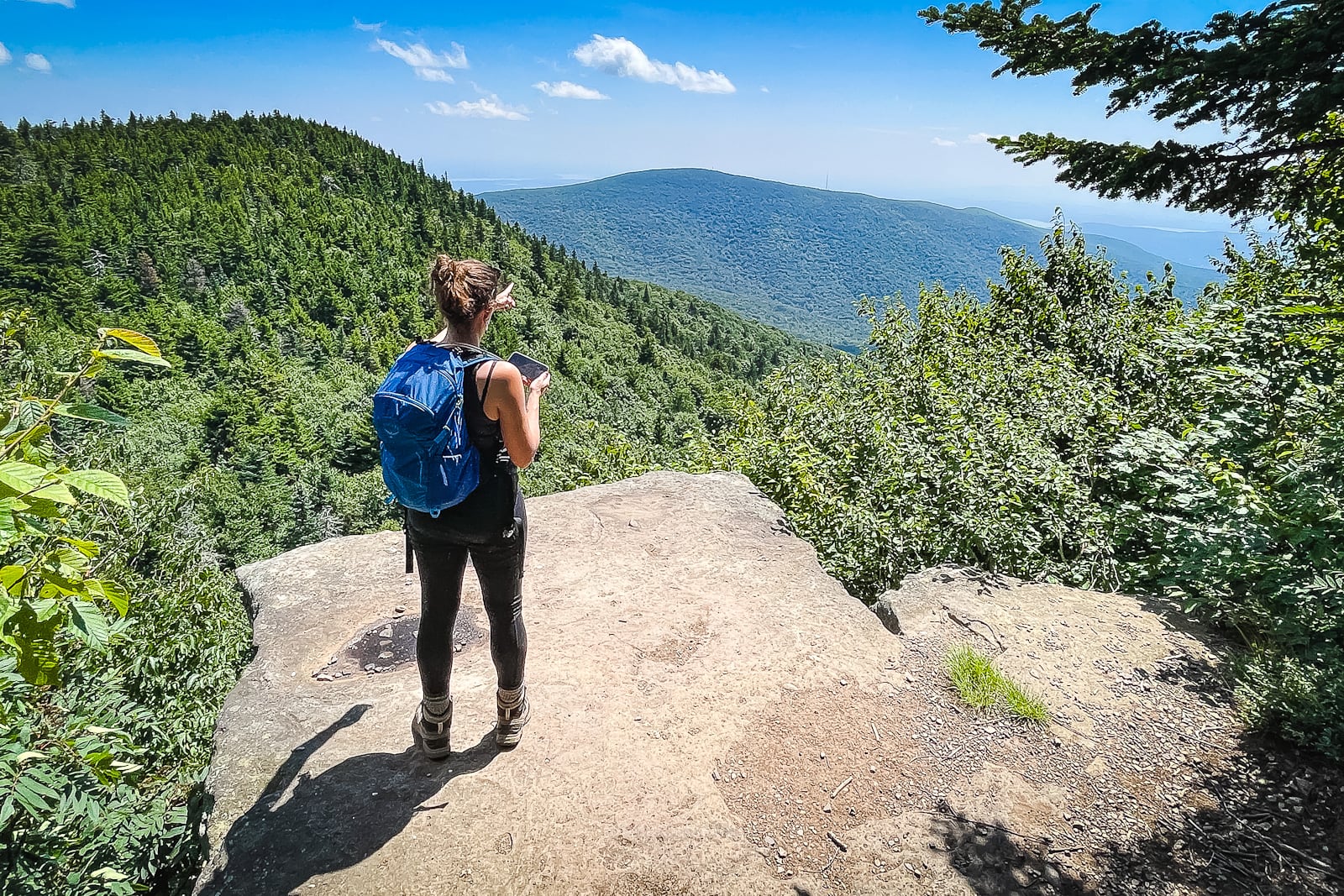
And let’s not forget the views: fantastic scenery from every mountain, including one of the best views (from Twin Mountain) in the entire Catskills Park.
If, like me, you’re not yet ready to tackle the full Devil’s Path traverse, the Eastern Devil’s Path is an excellent and do-able day hike for strong hikers who are looking for a significant challenge.
Even though it covers only half of the full Devil’s Path, this is still definitely one of the hardest hikes in the Catskills — according to my legs, knees, and toes.
I hope to hike the Eastern Devil’s Path at least once a year from now on. This was one of the most fun days I’ve ever had in the mountains.
BTW, you might also enjoy…
- UPDATED › Best Bug Spray & Bug Repellent for Hikers
- CATSKILLS › Peakbagging The Catskills High Peaks (Ultimate Guide)
- STAY › Find Your Perfect Catskills Stay
- ADIRONDACKS › Wright, Algonquin & Iroquois Peaks
- LEARN › Teach Yourself How to Use a Compass
- ENTERTAINMENT › Best & Worst Hiking Movies
- Follow › My Instagram @TotalCatskills
- Follow › My Substack @TotalCatskills
- Follow › My writing for Times Union
Eastern Devil’s Path Hiking Trail
The Eastern Devil’s Path hiking trail includes…
- An easy warm-up for the first two miles
- Then relentless up and down for the remaining 10 miles
- Some of the toughest trail sections in the Catskills
- 12 miles of tough trails
- 5000 feet of elevation gain
- 5000 feet of elevation loss
- Increasingly deep and steep notches
- Increasingly large mountains
- Increasingly higher summits
- This hike requires cars staged at both ends
Allow anywhere from 8-12 hours for this hike.

Eastern Devil’s Path Trail Notes & Gallery
Note: there’s only one reliable water source along this trail section, and it’s near the end. You must pack in (and out) all the supplies you need to complete this route. And you will need to stage cars at both ends, or arrange a taxi ride.
My hiking partner on this hike and I are both strong hikers. We loved the first 75% of this hike. The last 25% nearly killed us. We each considered completing this hike a major personal achievement.
My trail notes below include escape routes, as well as some before-and-after thoughts on the experience, which might inform your own expectations and planning.
In my planning for this hike, I used my normally very reliable hiking pace formula — I allowed 6 hours for trail length plus 2 hours for elevation gain. This gave me an estimate of 8 hours.
With some wiggle room, I figured 8-9 hours total.
In end, on a really favorable day (weather-wise), this hike took us almost 11 hours.
You can see the gory details on my AllTrails track.
Here is the elevation chart from the hike…
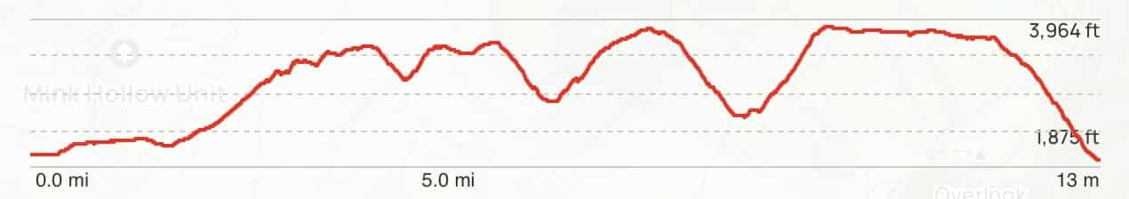
On the left, you can see the easy walk in, followed by the increasingly high summits and increasingly low and steep notches.
Coming down Sugarloaf and seeing the climb of Plateau ahead was… mentally taxing!
Car Staging
My hiking partner and I met in Stony Clove Notch and drove in one car to Prediger Trailhead.
Our plan was to hike back to the first car and grab dinner in Tannersville on the way back to Prediger — an excellent, excellent plan, undone only by how long it took to complete this hike. By the time we got to Tannersville, everything was closed. Waaa.
Bail-Out Points
If you need to bail on this hike, there are three obvious ways off the trail — three escape routes that become increasingly less appealing as the hike proceeds…
 You’ve got the basic details, but there’s so much more…
Unlock this site now to get complete intel on every route, including my full photo galleries, personal insights and tips. Elevate your next hike with deep trail beta. Experience hundreds of amazing routes at their absolute finest. With Mountain-Hiking.com, you’re not just skimming the surface.
Sean

Similar Hikes
Looking for a major hiking challenge in the Catskills? Check out The Complete Devil’s Path, Huckleberry Loop, Slide/Cornell/Wittenberg out-and-back, and The Burroughs Loop.
Read More
Get full access…
Get instant access to the full version of this site and enjoy great supporter benefits: full galleries, full trail notes, early access to the latest content, and more.
Hot on the website right now…
Follow for more…
Follow my @TotalCatskills content on Instagram for regular hiking inspo and safe, inclusive community.

Eastern Devil’s Path Trailhead
Large but very popular lot. Arrive as early as you can on popular days.
Google Maps Location: 42.134142, -74.104385
The map below shows the exact topographic location of the trailhead
Cell Service
Spotty coverage throughout, best signal up high, but no guarantees. My network is Verizon. YMMV.
2 responses to “Eastern Devil’s Path”
Your comments are welcome here…
The parent mountain for this hike is Indian Head.
I finished the entire Devil’s Path over the weekend and there is no doubt that the Eastern DP was the toughest hike I ever completed. I climbed Katahdin and walked the Knife’s Edge in a thunderstorm. I did 15 miles in the Dix Range in the Adirondacks and found that completely exhausting. Both of those hikes were easier than DP.
My average pace is 2 mi./hr. but it took me 9 hours to walk the eastern half. The descent from Sugarloaf and climb up Plateau was absolutely brutal. The final descent into Stony Clove Notch was the longest 1.2 mile hike of my life.
Since the summer air was super humid during my hike, I packed 1 gallon of water and a 16 oz. Gatorade. It lasted to Plateau summit.
As painful and strenuous as the eastern DP was, I didn’t fall or stumble once. My watch measured 13.5 miles from Prediger Road to our campsite at Devil’s Tombstone.
Oh, that’s so interesting to hear that you found it harder than Katahdin’s Knife Edge. I assumed that was a killer hike. But the EDP definitely is grueling. My friend and I were so so done and Plateau seemed to go on FOREVER. I didn’t fall once, either, but I did stumble in the very last mile on the way down into Stony Clove notch. I was so tired and I just knocked my big toe off of some rock — and the bruise stain from under my toenail literally just grew out in the last week or so! LOL.