Disclosure: This content may contain affiliate links. Read my disclosure policy.
A tough, steep, beautiful loop.
Trailhead info at bottom of this post.
With 3600 feet of elevation gain, this 8 mile loop route up and down Giant Mountain in the Adirondacks will test your legs — but the views from the summit, and from this descent route, are truly stunning.
Giant Mountain near Keene, New York, offers a series a steep and physically demanding hiking trails — and some of the most stunning wilderness scenery in the Adirondacks.
On a warm day, on any of these trails, there will be sweat. Before you hike Giant Mountain, make sure you have enough fluids: at least 3 liters per person, plus a Gatorade or something similar to replace lost electrolytes.
Giant Mountain Trailhead Parking
The trailhead for Giant Mountain is on the north side of Route 73, opposite the Adirondack Mountain Reserve (AMR) which provides access to The Lower Great Range, Noonmark, Dial/Nippletop, Indian Head, etc. The Giant Ledge lot is medium-sized and fills up quickly.
There are portable toilets at this lot.
I did this hike near the end of June, just before the summer hiking season really kicks off. I arrived at 9:15 am and there were several spots left. This is not always the case. I got lucky! Plan to arrive earlier.
BTW, you might also enjoy…
- UPDATED › Best Bug Spray & Bug Repellent for Hikers
- CATSKILLS › Peakbagging The Catskills High Peaks (Ultimate Guide)
- STAY › Find Your Perfect Catskills Stay
- ADIRONDACKS › Wright, Algonquin & Iroquois Peaks
- LEARN › Teach Yourself How to Use a Compass
- ENTERTAINMENT › Best & Worst Hiking Movies
- Follow › My Instagram @TotalCatskills
- Follow › My Substack @TotalCatskills
- Follow › My writing for Times Union
Hike Safely on Giant Mountain in the Adirondacks
Giant Mountain is so well-known, it’s on a lot of casual hikers to-do list. On this day, I saw many hikers wearing non-hiking footwear and carrying hardly any supplies. I was concerned to see so many people attempting what is a difficult and somewhat technical hike without The 10 Essentials.
I hiked this route when the mountain was bone dry and I was very glad. During the three warm seasons, personally, I would not attempt this hike after any rain. There are huge sections of rock slab and, up high, there are several oversized boulder scrambles. Super fun — but, after any rain, I would be challenged, personally, beyond the point of enjoyment. Learn how to enjoy hiking safely.
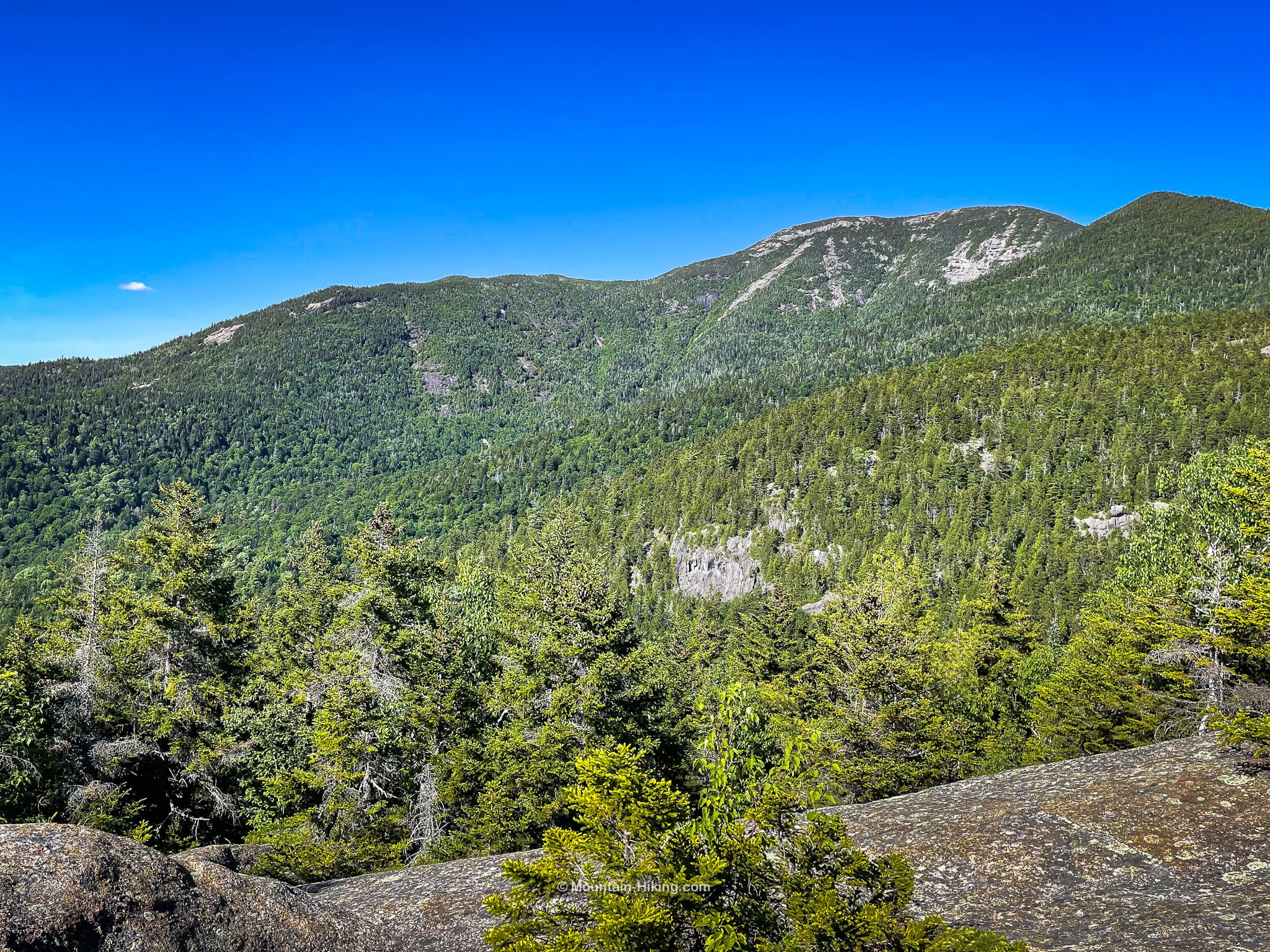
Giant Mountain Adirondacks Hiking Trail
All the trails on Giant Mountain are relentless. The trailhead for this climb is at 1300’ and the summit is at 4600’ — so you will climb 3300’ in about 3¾ miles. It took me about 3.75 hours to get to the summit, so I averaged about one mile per hour; this mountain slowed me down.
Although most hikers seem to be faster-paced than I am, I would still plan for a long day on this hill — partly just because you’ll be soaking in so many excellent views for so long. It’s an amazing mountain.
The terrain is lovely throughout, and ever-changing, which keeps this hike interesting the whole way. Down low there’s a mix of cool deciduous woods sprinkled with hemlock stands. Up high, there’s lots of spruce getting blasted in the sun, and smelling amazing, and even some cedar trees.
This Giant Mountain hiking trail includes…
- A fun stream crossing
- Persistently steep hiking trails
- A wooden mountain ladder
- Rock and slab scrambles
- Insane Adirondack wilderness views above 3000’
- A stunning scenic descent
Allow 7-9 hours for this route which includes Giant’s Nubble on the way out. A full breakdown is provided in the trail notes below, with 4 videos and 20 spectacular photos.
Giant Mountain Trail Notes & Gallery
Start at the trailhead and follow the red blazes.
This route passes the turn-offs for both the base and the top of Roaring Brook Falls. I did the upper falls on the way in and the lower falls on the way out.
Not far from the top of the falls, you’ll get to cross Roaring Brook itself …
 You’ve got the basic details, but there’s so much more…
Unlock this site now to get complete intel on every route, including my full photo galleries, personal insights and tips. Elevate your next hike with deep trail beta. Experience hundreds of amazing routes at their absolute finest. With Mountain-Hiking.com, you’re not just skimming the surface.
Sean

Similar Hikes
The terrain of this hike reminded me of my hike to Panther Peak in the Santanonis, but the amazing views reminded me of the views from Cascade Mountain, another very popular Adirondack 46er peak.
Read More
Get full access…
Get instant access to the full version of this site and enjoy great supporter benefits: full galleries, full trail notes, early access to the latest content, and more.
Hot on the website right now…
Follow for more…
Follow my @TotalCatskills content on Instagram for regular hiking inspo and safe, inclusive community.
Giant Mountain Trailhead
Medium-sized, very popular lot.
Google Maps Location: 44.150270, -73.767540
The map below shows the exact topographic location of the trailhead
Cell Service
You’ll have cell service the higher you climb. None at the trailhead. None down low. The situation improves above 2500ft. My network is Verizon. YMMV.
2 responses to “Giant Mountain”
Your comments are welcome here…
The parent mountain for this hike is Giant Mountain.
I hiked to the summit of Giant on 7/1. It was my first 46er. It was a cloudy day so the views were not as spectacular as during your hike, but we’re still amazing. I took the red-blazed trail on the ascent and descent, so I missed out on the spectacular views you mentioned on the blue-blazed trail by Giants Washbowl and Nubble. I also didn’t venture the few hundred yards along the trail toward RPR because it looked like rain showers were moving in and I knew those rock scrambles were going to be treacherous if wet so I wanted to get below them before that happened. I packed 3L of water but no electrolytes and I ran out of water on my way down. My legs just about gave out by the time I got back to my car at Roaring Brook Falls, but I managed to drive to The Mountaineer for a Gatorade and to get my Giant patch instead of passing out!
From your summary of your hike it is clear that I need to do this one again next time I’m on vacation and check out the alternate paths I didn’t take, and try for a clear weather day.
Yeah, it’s a beast of a hill! I only fully realized how much of a climb it was while I was writing it up. No wonder we were so beat! I did okay with my water — but I was feeling nervous toward the end. For future ADK hikes, I’ll freeze a Nalgene so I’ll have an extra liter of cold water. With my 2.5L reservoir and a large frozen Gatorade, that’ll give me just over 4L of water for a day hike. ¶ Congrats on doing your first 46er. Killer start!