Disclosure: Links to external websites on this page may be affiliate links. As an Amazon Associate I earn from qualifying purchases. This means, at no additional cost to you, I will earn a commission if you click through and make a purchase.
The classic route allows you to warm up slowly over fairly level terrain, then takes the super-fun turn up the eastern side of the mountain.
Hiking Trail Description
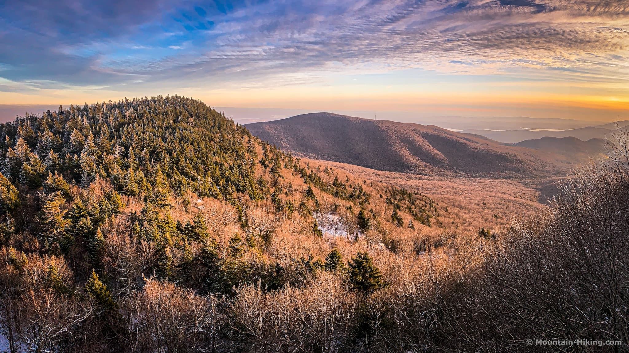
Indian Head is the smallest mountain on the infamous Devil’s Path trail. But it’s also the most delightful. The other five peaks are wonderful too, of course, each in their own way — the scale! the drama! the views! — but hiking Indian Head is a very special, intimate, and rewarding experience.
How to Get to Indian Head in Fall & Winter
Between November 1 and April 15 every year, the eastern end of Platte Clove Road is closed. Use this alternate route to Platte Clove Road. It takes only a little bit longer.
The parking area at the end of Prediger Road is a generous loop, with lots of space for cars, but this is a popular destination — even at lunchtime on this frigid weekend the lot was almost full.
Indian Head Hiking Trail
The register is right at the trailhead. After you sign in, follow the red blazes through a pleasant quarter mile of easy walking, until the first junction. Here, you could turn right and head up to the col between Indian Head and Twin via the Jimmy Dolan Notch Trail. That’s the short, steep route. Later, you’ll come down that way.

Instead, keep heading straight/east, along the base of Indian Head.
The next mile-and-a-half is rugged, but level and easy.
You might also enjoy…
- Read › Balsam Lake Fire Tower (Updated)
- Read › 9 Secret Spots in the Catskills
- Read › The Trail to Inclusivity
- Read › Survivor Bias
- Read › Catskills Farmers’ Markets
Indian Head has many stands of tall hemlock trees, often very old.


There’s plenty of water flowing on this side of the mountain and you’ll pass several drainages to your right.

To your left, through the bare trees, you can see Round Top and Kaaterskill High Peak. To their left, in the distance, you may be able to see Black Dome and Blackhead.
In cold weather, you may also come across some needle ice. Needle ice is formed when the air temperature is below freezing but the soil temperature is above freezing, and the soil is wet. Individual grains of dirt begin to grow ice needles via capillary action. The result is a patchwork of tiny ice-forests that look like melted toothbrush-heads. The first time I saw needle ice was on the Dix Range in the Adirondacks this fall, on the cold side of Macomb Mountain. Pick up some and crush it in your hand.


Where the trail crosses the 2250’ contour, there’s a sudden dip. The trail heads down to your left, before turning right and leveling out again.

Junctions & Quarry
At the second junction, there’s a small quarry on your left. At this time of year, you’ll see it through the bare trees. You’ll have to head down that trail (which goes to Platte Clove) for 50ft or so before entering the quarry on your right. The rock cairns don’t interest me much, but there are some nice deep crevices around the edge of the quarry.
Head back to the junction and turn left. 90 seconds later, you’ll be at the third junction. From here, you could continue straight ahead/south to the Devil’s Kitchen lean-to and Echo Lake. Instead, turn right/west and continue following the red Devil’s Path blazes uphill.

The first mile was basically flat. The second mile feels like a net loss of elevation. Now the ascent begins. The grade is moderate as the third mile switches back and forth between flat sections and small stepped inclines.
None of this is strenuous. Lots of places to catch your breath.
Hemlock Forest
From the third junction to the rocky section below Sherman’s Lookout is the most fantastic stretch of forest. All around are very large and very old hemlock trees. This area was untouched by the tanning industry of the 1800’s. It feels primordial, and is completely wonderful to walk through. It’s one of my favorite areas in the Catskills.
As you work your way out of the hemlock stands, the terrain gets rockier and the forest thins out.
This area is very wet and exposed. In cold weather, it freezes hard and fast. I saw two groups of people here, neither with any traction, which is absolute madness. There are rocky sections to climb and pass over, with the rocks completely encased in glaze ice. With spikes on, you can walk right through it, no issues. Without spikes, this stretch of trail is an ice-rink and concussion arena.


You’re not done with woods by a long shot. Indian Head has so many great patches of forest to walk through.
Sherman’s Lookout
There are three rock ledges on the way to Sherman’s Lookout. The first is just below 2750’. The second is around 2950’. The third one is at 3100’, and it’s the largest — to get past it, go around its right side.
Not far after the third ledge, you come to Sherman’s Lookout, which is down a very short spur trail on your left. If it’s iced-up, be careful and watch your footing. The view looks north across Platte Clove to Kaaterskill High Peak, at the base of which is the Bruderhof Community complex.
To the east (on your right) you’ll see Plattekill Mountain.
Head uphill again. At 3300’, you‘ll come to a fourth rock ledge. This one has a fun passage to climb though.
Indian Head: The Chin
Seen from a distance, Indian Head has the profile of a long human face that’s made from three knolls: a chin, a nose, and a forehead. The trail now winds around the easternmost of these knolls, the chin.
After a few minutes, you’ll have circumnavigated the chin and will be standing at the base of the nose.
The Rock Chute
One of the funnest sections to hike in the Catskill Park is this 60ft (20m) rock chute everyone loves to climb on Indian Head. It looks crazy from below but it’s actually quite do-able.
Start on the bottom right side of the cliff, where there’s a small ledge that’s just wide enough for footing. Then move up to the left, holding on to the sturdy roots as you climb.
It’s just so much fun. When you know you’ll be climbing this chute, you look forward to it all week long.
The Ledge
The view from the ledge at the top of the chute is *chef’s kiss*. You’re looking at the knoll you just walked around, which forms Indian Head’s chin.
Two miles away, to the right of the knoll, is Overlook Mountain. See if you can spot the radio tower on Overlook, and its fire tower.
The large body of water to the right/south is the Ashokan Reservoir — see the featured image for this post.
Between the knoll and Overlook, through the notch, you can just make out the Hudson River flowing south to New York City.
Behind the knoll, to its left, the northern flank of Plattekill slopes down toward Platte Clove.
Along the horizon, the line of low mountains you see are the Southern Taconics, thirty miles away: Mount Everett, Bash Bish Falls, etc.
The photo below (taken from Kaaterskill High Peak) shows Indian Head’s three summit knolls. The photo above is taken from the middle knoll (the nose), looking back at the leftmost knoll (the chin).
From the ledge, it’s about half a mile to the summit. The trail dips down one last time into the col between Indian Head’s nose and forehead, and then you begin your final ascent.
At 3400’ you’ll pass another view of the Ashokan Reservoir from a small rock ledge on your left.
Final Ascent
Right after this sign, you start climbing Indian Head’s final knoll.
The rest of the trail to the peak is classic Catskill boreal woods, rocks, roots, and moss. I love it.
Indian Head’s Summit
Indian Head’s summit is unremarkable. There are no views. But walking along the narrow channel, through the hemlocks and balsam firs, is wonderful. It’s very quiet and peaceful.
Descent From Indian Head
The trail heads down immediately. Like Twin and Sugarloaf, the western side of Indian Head is very wet. When temperatures drop, it gets iced-up quickly. The descent from the summit to Jimmy Dolan Notch requires some care and attention. Proper winter traction is a must — Kahtoola® MICROspikes® or Hillsound® Trail Crampons.
This small rock passage is great. (This photo is taken after I’d climbed down it, so I’m looking back.) If it’s iced-up, be careful and take your time. There are roots to hold onto, but take a minute to figure out how to do it safely.
The trail continues down the west side of the mountain.
You’ll come down around this enormous boulder without realizing, at first, how big it is. It’s almost always wet and, in the fall, glaze ice and icicles slowly encase it in fantastic ways.
Below this is a tricky, steep section. When iced-up, without spikes, you‘d toboggan down it in a heartbeat.

It took me 25 minutes to get down to the col. It was still before 5pm but the sun had set half an hour ago, and things were starting to look pretty spooky…

Jimmy Dolan Notch Trail
Turn right and head down the blue-blazed Jimmy Dolan Notch trail. The first section is very steep. Take your time and make sure you have solid footing with every step.
On the way down, if it’s still light enough, you’ll be able to see the Blackhead range through the bare branches, as well as Kaaterskill High Peak.

Below 2750’, the terrain is much less steep, but the trail is very lumpy and wet. I made the mistake of taking off my Hillsounds too soon and immediately slipped and fell on some ice I couldn’t see, even with my headlamp on. I sat on my butt, put my trail crampons back on, and walked out securely.
Blazing Issues on Jimmy Dolan Notch Trail
The blazing is not 100% on this trail. There are a few spots where, in the dark, you have to take your best guess.
In the Catskills, most trail blazes are reflective. They show up very well in the dark when your light hits them. But, right here, sometimes they’re just a little too far apart.
And there are a lot of sharp turns on this trail, which the doubled-up blazes will alert you to — if you can find them!
Walking Out
In the daytime, there are lovely sections of woods all around this trail, which passes over huge swaths of exposed roots and red soil.

In the summer and early fall, these woods are very alive at night. Thousands of insects fly in and out of your headlamp’s beam, and deer watch you pass from deep inside the forest. Around me now, though, in the early mountain winter, the woods were totally silent. As I approached the trailhead, all I could hear were the coyotes yipping high in the hills.
Similar Hikes to Indian Head
If you love Indian Head, the most obvious mountain to climb next is Twin, which you can access from Jimmy Dolan Notch, the col between the two summits.
For more of a low-key-day, try Balsam Mountain. If you’re not sure about tackling the Devil’s Path, try Balsam to feel yourself out.
Heading up to Giant Ledge and Panther makes for a longer day – but it’s suitable for anyone who can handle Indian Head.
Get full access…
Get instant access to the full version of this site and enjoy great supporter benefits!
Hot on the website right now…
- Best Breweries in The Catskills
- Overlook Mountain Trail
- Best Catskills Fall Foliage Hikes
- Huckleberry Point
- Devil’s Path Trail (Ultimate Guide)
Follow for more…
Follow my @TotalCatskills account on Instagram for regular hiking inspo and safe, inclusive community.
The parent mountain for this hike is Indian Head.
If you do this hike, LMK how it went…
6 responses to “Indian Head Hiking Trail (Best Route)”
Your comments are welcome here…
Trailhead Info for this Hike
The circular parking area is quite large but fills up quickly on weekends.
Google Maps Location: 42.133939, -74.104120
The map below shows the exact topographic location of the trailhead
Cell Service
Indian Head is somehow in a decent spot for cell service, but coverage is flaky. For the first half of the hike, you’ll wander in and out of service. From the summit, you can get a weak signal. When you start heading down Jimmy Dolan notch, the signal drops more often than not. However, back at the trailhead, I was able to get texts out from the parking area. My network is Verizon. YMMV.
Must have missed the 3400’ sign, Sean. Would have made my day having a picture next to it.
That one is easy to miss. Next time!
Mid September must be one of the best times to summit Indian Head.
For the best experience, I’d encourage a clockwise way of summering and then looping back.
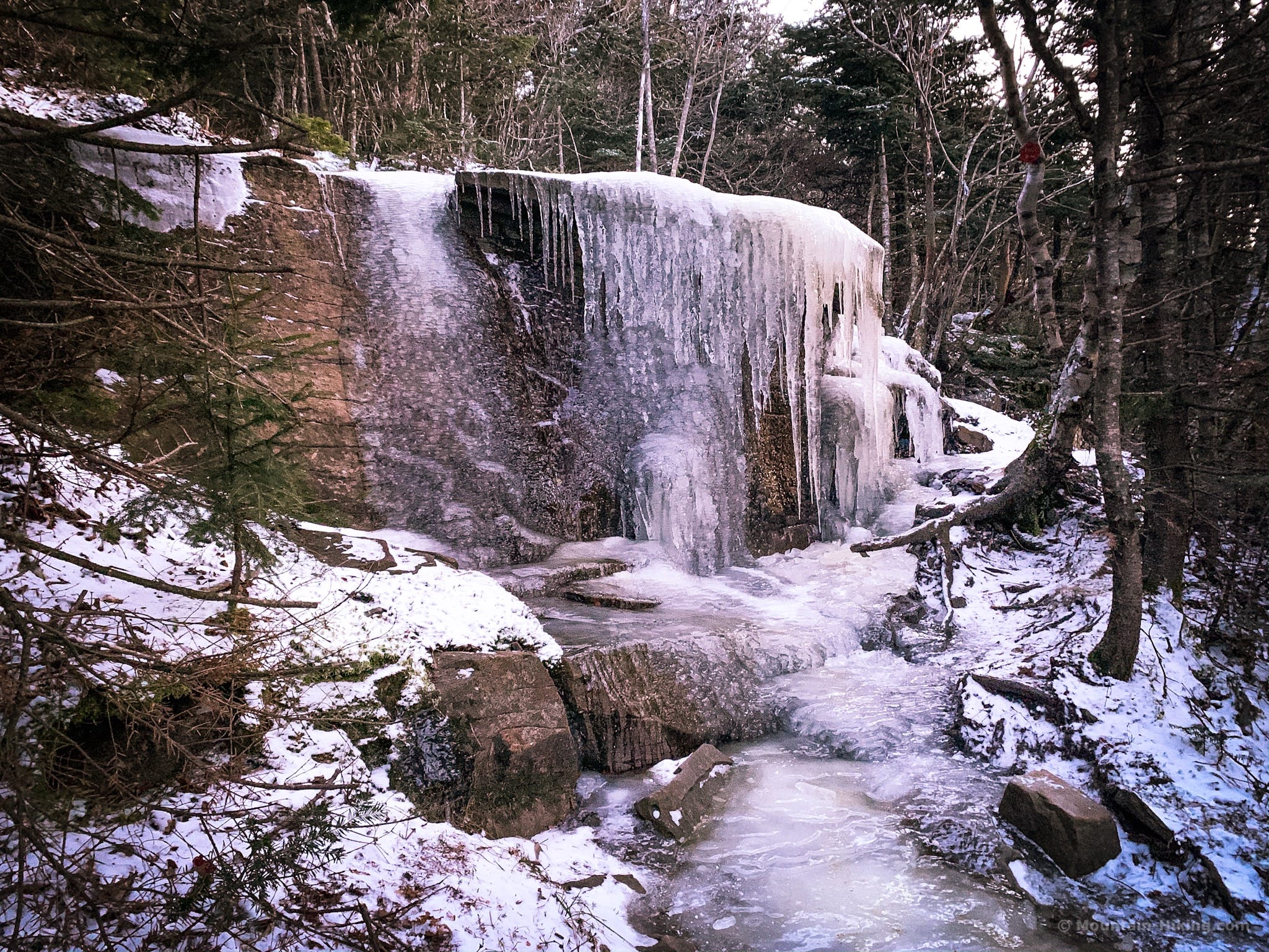
We headed out mid morning, signed in at the trailhead and moved through the forest. Slowly making it higher and higher. There are a LOT of roots and you’ll need to keep your feet high so as not to catch your boots and suffer an reverse ego trip. The ground was damp and to some extent wet , but never over the toes of my boots. All of this time we wore baselayers and a vest – it was low 50°’sF.
At the junction the trails switches from red to blue markers this is where the work begins. Roots turn to rocks but the forest is spectacular and you’ll be covered from any showers, should they happen and the effort is made all the more charming with the vistas.
Be prepared to sweat a little on the ascent. You’ll know you’re on the right route when you come across the blue baseball hat from Maine!
At the upper parts of this section you’ll need to make three climbs, almost vertical and you can thank heavens for Mother Nature and her profuse roots that you can hang onto as you make your way up.
The first lookout is simply spectacular and the following ones build on it.
As with many peaks in the Catskills, the summit is not much to write home about and we simply walked past and started the descent.
While the ascent was roots and damp ground with a couple of near verticals, the descent is knee jarring, energy sapping and became frankly annoying. It just makes sense to have a nice time on your way up and thank you Sean @mountain-hiking.com for the recommendation to go clockwise.
Our loop took 4+hrs and we’ll sleep well tonight. Have fun. Be safe and healthy and please. Wear a mask when you meet others on the trail.
Glad you had a good time! One of my favorite mountains.
Something kinda cool to note, the buildings in the photo from Sherman’s lookout is the old NYC Police Camp where policemen and their families gathered on vacation every summer for decades. Ironically, my dad had been telling me about this camp where he had spent many summers with his parents. We stepped out onto Sherman’s lookout and there it was! He was so excited to see it from the lookout. He couldn’t recall exactly where it was until he saw it from the ledge 🙂
Your dad is the second person to mention the old old police camp there. How wild. Or maybe he’s the same guy who told me about it before?