Disclosure: This content may contain affiliate links. Read my disclosure policy.
A very long, very tough route.
Trailhead info at bottom of this post.
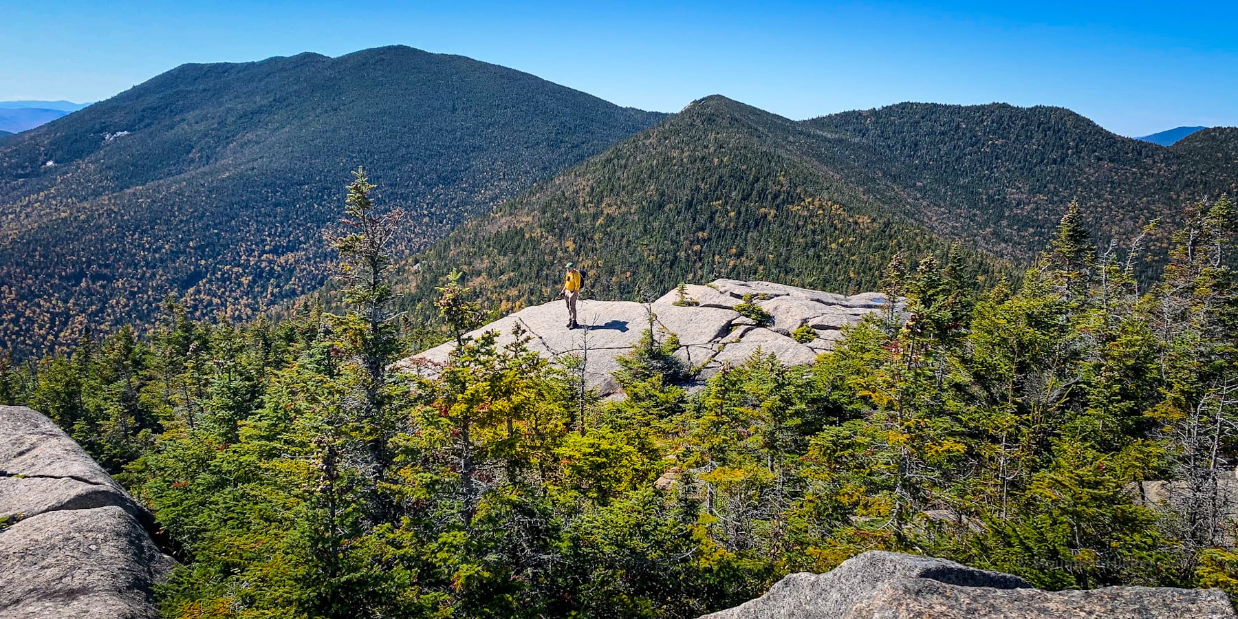
At 16-20 miles, and with 5500 ft of elevation gain, hiking the Dix Range is one of the longest and most challenging day hikes you can do in the Adirondacks — but the rewards are absolutely insane.
To date, this is by far the most amazing and memorable hike I’ve done. Dix Range terrain is grueling but the views are astonishing. This hike is crazy crazy crazy good.
I’m awestruck by anyone who can complete the Dix Range in a day. The first time I tried to complete this Range, I failed. I had to break this hike into two separate trips!
I completed the first half of the Dix Range (Macomb, South Dix and Grace Peak) in 2019. By the time I made it half way to Hough, I knew my legs were shot. Wisely, I bailed down the Lilian Brook trail. I made it back to my car on fumes, truly, shuffling like the walking dead.
I completed the second half of the Dix Range (Hough, The Beckhorn, and Dix Mountain) in 2021. I fared much better the second time, on stronger legs — but I also had a cute strategy to shave off some effort, which you can read more about at the bottom of this post.
BTW, you might also enjoy…
- UPDATED › Best Bug Spray & Bug Repellent for Hikers
- CATSKILLS › Peakbagging The Catskills High Peaks (Ultimate Guide)
- STAY › Find Your Perfect Catskills Stay
- ADIRONDACKS › Wright, Algonquin & Iroquois Peaks
- LEARN › Teach Yourself How to Use a Compass
- ENTERTAINMENT › Best & Worst Hiking Movies
- Follow › My Instagram @TotalCatskills
- Follow › My Substack @TotalCatskills
- Follow › My writing for Times Union
Dix Range Trailhead & Parking
The parking situation for the Dix Range changes according to season.
There are two main lots: a small inner lot at the trailhead (near Elk Lake), and a large outer lot (south of Clear Pond) about 2¼ miles from the inner lot.
Unless you are very early, and very lucky, and get a spot at the inner lot right next to the trailhead, it’s likely you’ll begin your hike at the outer lot near Clear Pond. In October, during leaf-peeping season, both lots fill up long before 6:00 am.
Starting at the inner lot at the trailhead, the main loop is probably 15 miles. But having to hike in from, an back out to, the outer lot adds 4½ miles — which is apx 2 hours hike time — to your day.
The GPS route attached above includes the hike in from the outer lot, as that’s how I’ve done it both times.
You also need to factor in…
Seasonal Trail & Road Closures
The DEC page for the Dix Mountain Tract states…
“The Elk Lake Trailhead and the first 2.3 miles of the trail accessing the Dix Mountain area are on private lands. The public has the right to use the trail but is prohibited from leaving the trail and trespassing on private lands. The trail is closed during northern zone regular big game hunting season. After big game hunting season, the trail reopens. However, beginning then, and through the winter and spring mud season, the public must park 2.0 miles back from the trailhead at the Clear Pond Parking Area.”
Camping in the Dix Range
Factoring in your drive-time to and from the Elk Lake trailhead, hiking the Dix Range makes for a very long day.
Many people choose to hike in to one of the primitive campsites at the base of the mountains and begin hiking the Dix Range the next morning.
There are multiple large flat areas, perfect for camping, around the Slide Brook Lean-To. They are strewn all around the junction with the herd path that leads to Macomb. (Sometimes, there are so many tents in the woods, it takes on a village atmosphere.)
A second set of primitive campsites can be found another 1¼ miles along the Hunters Pass Trail, around the Lilian Brook Lean-To.
Both are spectacular, super fun settings, deep in the Adirondack Wilderness. The Dix Range is very special. Please make sure to leave no trace.
Dix Range Hiking Trail
Make no mistake: this is a long, tough and rugged, but intensely breathtaking hike. The Dix Range is often described as a five mountain range but, really, it includes six summits. The Beckhorn, between Hough and Dix, is a tidy little summit but it’s a substantial obstacle. It’s best to think of the Dix Range as a six summit range.
Technically, you have to hike South Dix twice, so pack enough snacks and hydration for seven summits!
Like many Adirondack High Peaks hikes, any hike of the Dix Range begins with a long walk-in. Depending on your starting point, you will walk for 2-5 miles to the junction with the Macomb herd path. At least the terrain is relatively flat—at first. Here’s the elevation profile from my GaiaGPS route.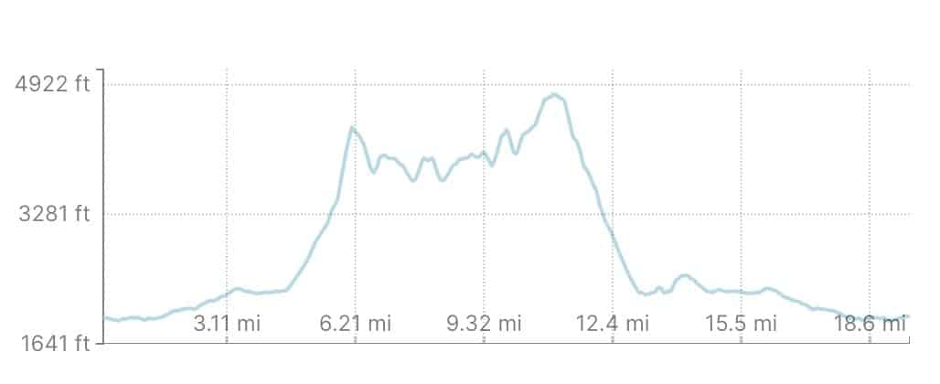
From the trailhead proper, after two miles or so, you’ll cross a stream and a large drainage.
Keep an eye on the right side of the trail for a small unofficial yellow blaze affixed to a tree, with “MACOMB MT” handwritten on it, above an official DEC yellow camping blaze.
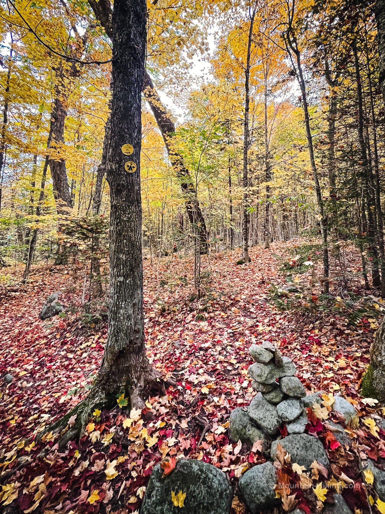
It’s easy to walk past this modest trail sign when you don’t know where it is.
In 2019, there was no cairn. In 2021, the above cairn had been added. The yellow blazes are a more reliable indicator.
A full breakdown of this hike is provided in the trail notes below, with 35+ breathtaking photos and 7 videos.
Macomb Herd Path
Warning: once you step off the main official trail, you will be following an unmarked, unblazed, and unofficial herd path over most of the Dix Range. Adirondack herd paths are usually easy to follow, but there are junctions where things can get tricky. And so…
Strong backcountry navigation skills are a must for any hike in the Dix Range. Specifically, you must be able to navigate confidently using map and compass, without your phone. Between selfies, photos and video capture, there is a strong likelihood your phone’s battery will completely drain on this hike.
The herd path winds easily uphill through a mix of deciduous and coniferous forest before eventually descending briefly to cross Slide Book.
Straight away you see you are at the bottom of Macomb Slide.
The Dix Range was my first Adirondack hike, and Macomb Slide was my first time climbing a slide. The scale of devastation wrought by a mountain slide is shocking.
Macomb Slide is steep and packed with loose dirt, but nothing grows there. It is wet; on cold nights, much of the slide is covered in needle ice. The terrain is very tiring, two-steps-forward-one-step-back type stuff. And it’s long.
Even though the slide only goes half way up the mountain, it took me over an hour to get from the bottom of the slide to the summit of Macomb Mountain.
However, this is also the first section where the famous Dix Range views begin to open up as this video shows…
 You’ve got the basic details, but there’s so much more…
Unlock this site now to get complete intel on every route, including my full photo galleries, personal insights and tips. Elevate your next hike with deep trail beta. Experience hundreds of amazing routes at their absolute finest. With Mountain-Hiking.com, you’re not just skimming the surface.
Sean


Similar Hikes to Dix Range
In terms of length and difficulty, you’re looking at major Adirondack hikes like the Santanoni Range and the Lower Great Range.
In The Catskills, the most comparable hike would be The Devil’s Path or the Burroughs Range Loop.
Read More
Get full access…
Get instant access to the full version of this site and enjoy great supporter benefits: full galleries, full trail notes, early access to the latest content, and more.
Hot on the website right now…
Follow for more…
Follow my @TotalCatskills content on Instagram for regular hiking inspo and safe, inclusive community.
Dix Range from Elk Lake Trailhead
This outer lot is larger than the trailhead lot, and is likely where you’ll have to begin your hike. From here, it’s 2.25 miles of road walk to the trailhead.
Google Maps Location: 43.991848, -73.830642
The map below shows the exact topographic location of the trailhead
Cell Service
No service at trailheads / parking lots. I had spotty service up high. Very high. My network is Verizon. YMMV.
The parent mountain for this hike is Dix Mountain.