Disclosure: This content may contain affiliate links. Read my disclosure policy.
A long hike in and out, but the summit has so much.
Trailhead info at bottom of this post.
Hiking Trail Description
This hike starts from Platte Clove and winds around the east side of Kaaterskill High Peak to tackle the final ascent via the northern ridge. You’ll hit all the major points of interest.
Kaaterskill High Peak is said to be neglected but, on this day, there were 20 people ahead of me in the register. Some hikers may have been going to Huckleberry Point, a popular short hike, but I met plenty of people on the mountain itself too.
Every week, online, I see new photos from Kaaterskill High Peak. With hiking numbers up across the country, KHP seems to be back on the hiking radar.
BTW, you might also enjoy…
- UPDATED › Best Bug Spray & Bug Repellent for Hikers
- CATSKILLS › Peakbagging The Catskills High Peaks (Ultimate Guide)
- STAY › Find Your Perfect Catskills Stay
- ADIRONDACKS › Wright, Algonquin & Iroquois Peaks
- LEARN › Teach Yourself How to Use a Compass
- ENTERTAINMENT › Best & Worst Hiking Movies
- Follow › My Instagram @TotalCatskills
- Follow › My Substack @TotalCatskills
- Follow › My writing for Times Union
Kaaterskill High Peak Hiking Trail
During the warmer months, when the eastern side of Platte Clove Rd is open, the dramatic drive up the winding cliff road is always 50% fun / 50% nerve-wracking — they close this route in winter for a reason. (Here’s the alternate route to use when Platte Clove Road is closed.)
The parking lot for this hike is the same one you use for hiking to Huckleberry Point, to visit Plattekill Falls, or even to hike into Echo Lake. The lot is large enough but it fills up quickly on busy weekends.
The Kaaterskill High Peak hiking trail includes…
- A long, muddy walk in
- Many, many junctions
- Mohawk camp site
- Two plane wrecks
- A 3500 canister
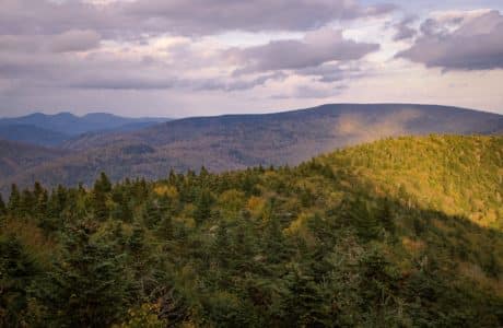
- Amazing view from Hurricane Ledge
- Pine Planes
Allow 5-6 hours for this hike. A full breakdown is provided in the trail notes below, with 23 remarkable photos.
Trail Notes & Gallery
This route is a nocturne: it has a calm beginning, a burst of high drama, then a return to calm.
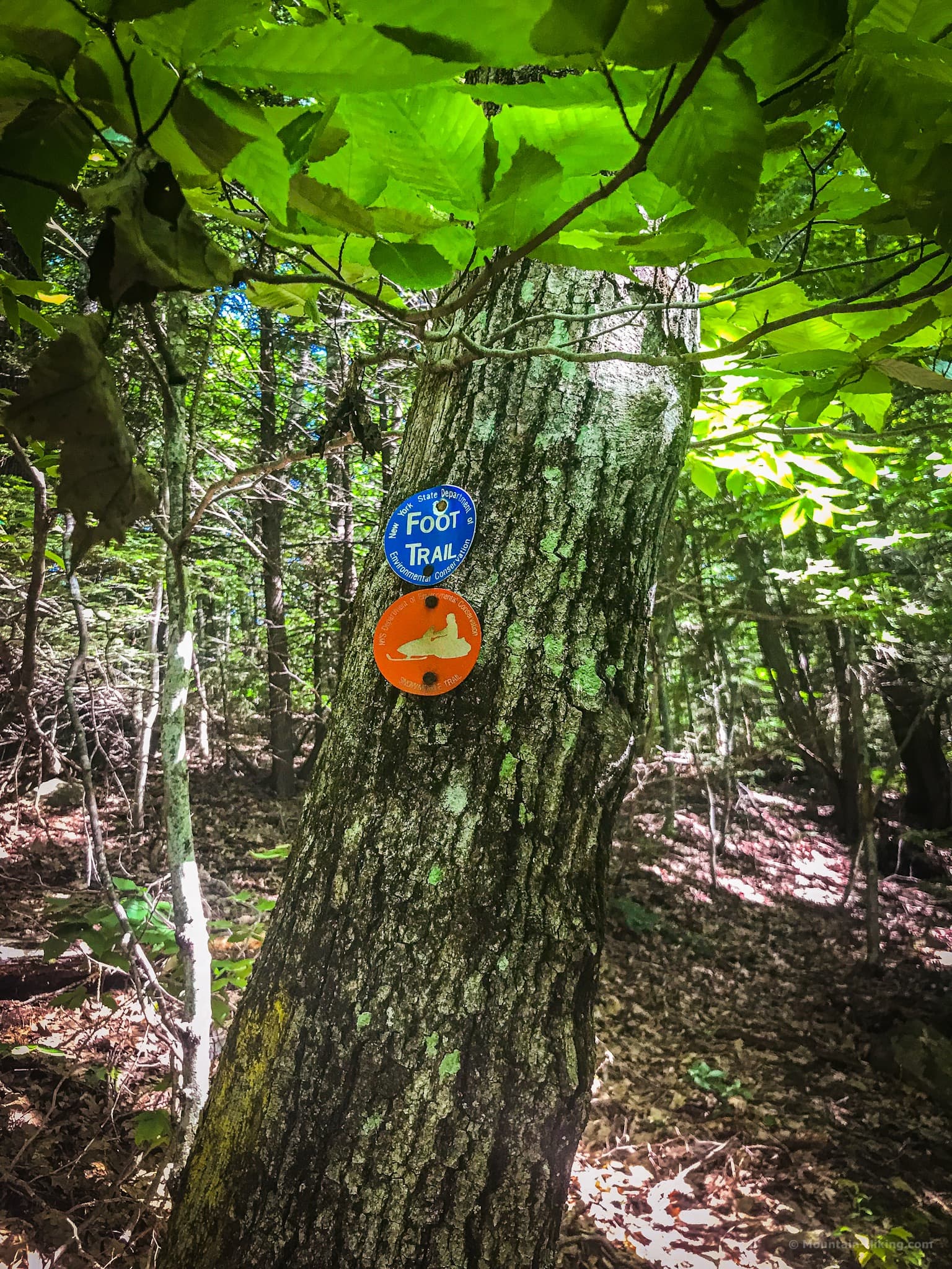
The register is on the west side of the lot, and marks the entrance to the trail. Sign in and begin your hike on the blue trail, heading north.
Cairns & Blazes
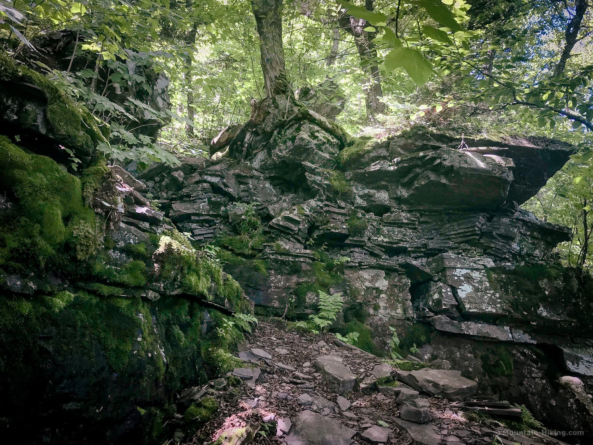
I was surprised to see so many cairns on the lower portion of this hike. They kept me company for quite a while, marking entry points into the woods heading west. I heard a lot of animal activity in this area. I suspect the cairns may be markers placed by hunters.
This trail is also a snowmobile trail so the trail blazes are doubled up: blue and red together.
After you pass the junction with the yellow trail, the woods switch abruptly to a hardwood stand. For the next while, the flora switches back and forth between hardwood and deciduous forest, over very wet and swampy terrain.
This hike is known for its long stretches of deep, thick mud — so a pair of gaiters is a good idea for this hike.
There are several footbridges to cross. The brooks and streams are very lively…
 You’ve got the basic details, but there’s so much more…
Unlock this site now to get complete intel on every route, including my full photo galleries, personal insights and tips. Elevate your next hike with deep trail beta. Experience hundreds of amazing routes at their absolute finest. With Mountain-Hiking.com, you’re not just skimming the surface.
Sean

Similar Hikes
This was my final Catskill 3500 hike. It was such a great mountain to finish on. From Hurricane Ledge, I was able to look directly across at Indian Head where my mountain hiking journey began. That was a very special feeling.
If you’re working on your 3500’s, keep a few special ones for the end: Sugarloaf, Black Dome, Twin, Hunter and Balsam Lake all offer wonderful views of multiple Catskill peaks. It’s such a nice way to bring your quest to a close.
Read More
Get full access…
Get instant access to the full version of this site and enjoy great supporter benefits: full galleries, full trail notes, early access to the latest content, and more.
Hot on the website right now…
Follow for more…
Follow my @TotalCatskills content on Instagram for regular hiking inspo and safe, inclusive community.

Hike Kaaterskill High Peak & 2 Plane Wrecks Trailhead
Medium-sized lot. Fills up early on busy weekends and holidays.
Google Maps Location: 42.133525, -74.082396
The map below shows the exact topographic location of the trailhead
Cell Service
No signal down low. Patchy up high. My network is Verizon. YMMV.
6 responses to “Hike Kaaterskill High Peak & 2 Plane Wrecks”
Your comments are welcome here…
The parent mountain for this hike is Kaaterskill High Peak.
Went there today but stopped abit before making our way to the top. I hear alot about the crashes n Mohawk home but didn’t see anything.. how close at the these sites to the top. If anyone know 100% please email me scorpiontattoo79@gmail.com
Do you have coordinates for either or both of these planes? Would make this a lot easier to follow!
Did KHP from the North 11/20 – we “almost” needed spikes, but there was enough ice-free rock to get to the top. Did it again on 11/24 via Hurricane Ledge. It was noticeably colder than the 20th, but sunny, so the southern exposure meant HL was mostly ice free. Good idea, this time of year, to carry traction (spikes and/or crampons) just in case.
Absolutely, and thank you for the trail reports! Glad you had two great hikes up there.
This was very helpful. There are a few spots where you say East when you should mean West that might be confusing.
“After about 2¼ miles, I came to the junction with a herd path that leads off the main trail. It appears on your left, and heads east, just before main trail bends northeast.”
I ended up doing the peak from the Southern side. It was steep as you got close to the top but as long as you paid attention to the route and didn’t go up a wrong steeper way it wasn’t bad and was a fun way to do the loop.
Dallas, thanks so much for catching this. I try very hard to not make that kind of mistake, and always double-check my east/west directions — but somehow this one slipped past. Really appreciate your catching it. I have updated the text. // I’m looking forward to trying that southern climb!